Filter: Categories of Wisconsin Historical Images
Filter: FULL_DATE of 1936
Filter: Subject of roads
Filter: Categories of Wisconsin Historical Images
Filter: FULL_DATE of 1936
Filter: Subject of roads

| Date: | 1936 |
|---|---|
| Description: | This map is red and black ink on tracing cloth and is oriented with north to the upper left. This hand-drawn map shows a central portion of the military ro... |
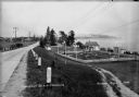
| Date: | 1936 |
|---|---|
| Description: | Crescent Beach campsite with cabins and miniature golf course by Lake Michigan. |
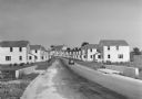
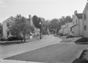
| Date: | 1936 |
|---|---|
| Description: | View down road of mass-produced residential housing with farm in background. |
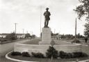
| Date: | 1936 |
|---|---|
| Description: | View of a boulevard containing a Spanish war memorial statue. The plaque on the statue's base reads: "Memorial to those who served in the war with Spain, 1... |
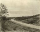
| Date: | 1936 |
|---|---|
| Description: | Roadimprovements along the portion of US Highway 16 known as the La Crosse-West Salem Road. At the time, this road represented the ultimate in modern high... |

| Date: | 1936 |
|---|---|
| Description: | A view of Fort Crawford after restoration. |

| Date: | 1936 |
|---|---|
| Description: | A view of the Indian Agency house after restoration. A person is standing on the porch. |

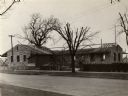
| Date: | 1936 |
|---|---|
| Description: | Merrill Hall and other smaller buildings from across the street. |
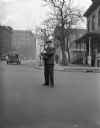
| Date: | 1936 |
|---|---|
| Description: | J. Robert Taylor standing in the middle of a street, holding a large camera. On the left, a car is driving by, and a person is walking on the sidewalk in t... |
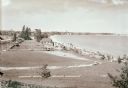
| Date: | 1936 |
|---|---|
| Description: | Elevated view of Crescent Beach, with campsite with cabins and miniature golf course and other outbuildings. Downtown buildings can be seen in the backgrou... |

| Date: | 1936 |
|---|---|
| Description: | Two men sharpen knives with equipment carried by an International truck. Original caption reads: "C-5 equipped with special body, owned by John Ciffone, co... |

| Date: | 1936 |
|---|---|
| Description: | A man is using an International I-30 industrial tractor with front loader to scoop gravel into the bed of an International truck owned by People's Gas Comp... |
| Date: | 1936 |
|---|---|
| Description: | View from lawn of curved residential street lined with recently constructed housing and lampposts. A car sits in a driveway of a house on the left, and fur... |

| Date: | 1936 |
|---|---|
| Description: | View up residential street with newly constructed houses, young trees and lampposts. Men in suits and hats walk along the sidewalk. A speed limit sign is o... |
| Date: | 1936 |
|---|---|
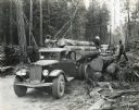
| Description: | Men use two International C-60 trucks to haul logs down a dirt road in a wooded setting. |

| Date: | 1936 |
|---|---|
| Description: | International C-1 truck parked in front of a Safeway grocery store in Prince Albert, Saskatchewan, Canada. |
| Date: | 1936 |
|---|---|
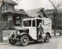
| Description: | Man getting out of an International M-3 truck owned by the Golden Guernsey Dairy. The truck is parked on a residential street, and the driver is carrying a... |
| Date: | 1936 |
|---|---|
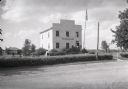
| Description: | Exterior view from across road of the first Wisconsin territorial Capitol building, as restored, in Old Belmont (later changed to Leslie). |
If you didn't find the material you searched for, our Library Reference Staff can help.
Call our reference desk at 608-264-6535 or email us at: