Filter: Categories of Wisconsin Historical Images
Filter: FULL_DATE of 1940
Filter: Creator Name of Wisconsin. Conservation Department.
Filter: Subject of outdoor photography
Filter: Categories of Wisconsin Historical Images
Filter: FULL_DATE of 1940
Filter: Creator Name of Wisconsin. Conservation Department.
Filter: Subject of outdoor photography
| Date: | 1940 |
|---|---|
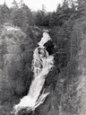
| Description: | Big Manitou Falls with trees and observation area. |
| Date: | 1940 |
|---|---|
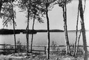
| Description: | View of trees along a fence in front of Boulder Lake. |
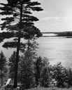
| Date: | 1940 |
|---|---|
| Description: | View down steep hill through trees towards a rowboat tied to a pier on High Lake, with the far shoreline in the distance. |
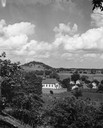
| Date: | 1940 |
|---|---|
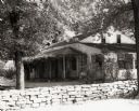
| Description: | Church, several houses and field from a hill. |
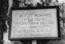
| Date: | 1940 |
|---|---|
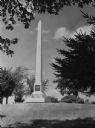
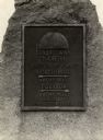
| Description: | Fort Howard hospital marker that reads: "Old Fort Howard • 1816 • This building formerly stood with the surgeons quarters and the powder magazine by the ri... |
| Date: | 1940 |
|---|---|
| Description: | View of the Tank cottage. The cottage was built about 1803 by Joseph Roi, a fur trader, who lived in it until 1805 when it was purchased by Jacques Porlier... |

| Date: | 1940 |
|---|---|
| Description: | View of the Jeremiah Curtin house located at 8685 West Grange Avenue. This stone and stucco residence was erected in the mid-1830s by Irish immigrants Davi... |
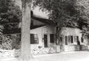
| Date: | 1940 |
|---|---|
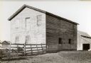
| Description: | Building used as a lodging house for the First Territorial Legislature held in Belmont in 1836. |

| Date: | 1940 |
|---|---|
| Description: | Building used as a lodging house for the First Territorial Legislature held in Belmont in 1836. |
| Date: | 1940 |
|---|---|
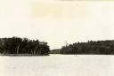
| Description: | View of Taylor Lake and the entrance to Chain O' Lakes. |
| Date: | 1940 |
|---|---|
| Description: | A view of a marker on highway 41 designating the half way point between the Equator and the North Pole. |
| Date: | 1940 |
|---|---|
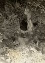
| Description: | A view of some caves at Peninsula State Park. |

| Date: | 1940 |
|---|---|
| Description: | A group of people, including two men, two women and a youth, is gathered around a campfire on a beach in the Kettle Moraine State Forest. One of the women,... |

| Date: | 1940 |
|---|---|
| Description: | A man is standing and looking at the door of the boathouse on the beach near the Twin River (Rawley) Point Lighthouse. The boathouse has stone sides and a ... |

| Date: | 1940 |
|---|---|
| Description: | A log gate and log-framed sign mark the entrance to the Twin River (Rawley) Point lighthouse. The keeper's house is next to the light and has a turret and ... |

| Date: | 1940 |
|---|---|
| Description: | Nine unidentified men and women on horseback are posing in front of the lodge at Point Beach State Forest. A young girl wearing a swimming suit is sitting ... |

| Date: | 1940 |
|---|---|
| Description: | An unidentified woman is posing sitting on the sand and looking toward Lake Michigan. The newly built shelter house, with its large windowed bay and massiv... |

| Date: | 1940 |
|---|---|
| Description: | View from pier towards a young couple sitting in the back of a wooden boat tied to a pier in Peninsula State Park. Fish Creek Harbor is in the background, ... |
If you didn't find the material you searched for, our Library Reference Staff can help.
Call our reference desk at 608-264-6535 or email us at: