 Filter: Categories of Wisconsin Historical Images
Filter: FULL_DATE of 1940
Filter: Subject of cities and towns
Filter: Subject of economics
Filter: Categories of Wisconsin Historical Images
Filter: FULL_DATE of 1940
Filter: Subject of cities and towns
Filter: Subject of economics
| Date: | 1940 |
|---|---|
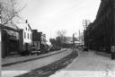
| Description: | The 600 block of Williamson Street ("Machinery Row") with the old Fauerbach Brewery in the background. |
| Date: | 1940 |
|---|---|
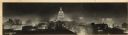
| Description: | Panorama view, elevated, of the Wisconsin State Capitol at night from the roof of a building on Monona Avenue. The First National Bank and the Belmont Hote... |
| Date: | 1940 |
|---|---|
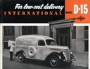
| Description: | Advertising brochure for International Model D-15 delivery trucks. Features an image of a driver unloading linen from a delivery truck owned by Atlas Linen... |

| Date: | 1940 |
|---|---|
| Description: | Elevated view of East Mifflin Street on the Capitol Square. The Strand Theater is on the right. Automobiles are parked at an angle on both sides of the str... |

| Date: | 1940 |
|---|---|
| Description: | Looking East down middle of avenue. Numerous vehicles are on the road, with a few pedestrians visible. A sign identifies the Republican Hotel on the left, ... |

| Date: | 1940 |
|---|---|
| Description: | Looking east on Wisconsin Avenue in the 800 block between 8th and 9th Streets. Cars are parked and driving down the street. An apartment block called the B... |
| Date: | 1940 |
|---|---|
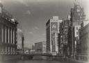
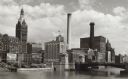
| Description: | View from the Wisconsin Avenue Bridge. A building on the left has a large sign for Gimbel's on its roof. Beyond the river in the background are two large s... |
| Date: | 1940 |
|---|---|
| Description: | A view north of Wells Street with a bridge on the right. Two large smokestacks, and a tall building with a clock break up the skyline. On the left is a bil... |
| Date: | 1940 |
|---|---|
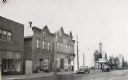
| Description: | View across street of storefronts, including a barbershop, and a sign reading "Alamo" above a marquee that says "Free Poultry and Country Store". The 1100 ... |
| Date: | 1940 |
|---|---|
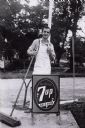
| Description: | Future District Court Judge William Sachtjen, wearing an apron and holding a broom. He is standing behind a 7-Up sign. Sachtjen worked at Droster's Grocery... |
| Date: | 1940 |
|---|---|
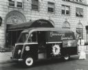
| Description: | A man in a uniform standing at the back of an International Metro truck with one leg up on the bumper. He is writing on a pad held on his knee, and there i... |

| Date: | 1940 |
|---|---|
| Description: | International model D-2-M truck with 115-inch wheelbase and Metro body. A man in a hat on the left is walking away from the van with some boxes towards Go... |
| Date: | 1940 |
|---|---|
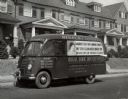
| Description: | International model D-15-M truck with a 113-inch wheelbase and a Metro body owned by the Regal Laundry. According to the original caption, the truck was o... |
| Date: | 1940 |
|---|---|
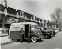
| Description: | Mr. Kuss of International Harvester's Chicago North Side Branch with an International model D-2-M truck with a 102-inch wheelbase and a Metro body. Mr. Kus... |
| Date: | 1940 |
|---|---|
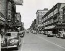
| Description: | Automobiles driving down Main Street, which is lined on either side with storefronts and buildings. On the left side of the street is Hotel LaFayette. On t... |
| Date: | 1940 |
|---|---|
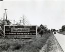
| Description: | An automobile drives down a road near a billboard advertising the Simpson Motor Truck Company, an International truck dealership. The original caption read... |
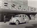
| Date: | 1940 |
|---|---|
| Description: | An International D-30 automobile with a special bulletproof body parked outside the Esquire Theater. Two police officers are standing near the vehicle, and... |

| Date: | 1940 |
|---|---|
| Description: | Map features advertisements for local businesses on the left and bottom. Map includes a "LEGEND" and "DIRECTORY OF CHURCHES". Streets are labeled as are so... |

| Date: | 1940 |
|---|---|
| Description: | This map of Aztalan is pencil and ink on paper. The map shows streets, local businesses, churches, houses, and the Crawfish River. The map reads: "Informat... |

| Date: | 1940 |
|---|---|
| Description: | Looking north on Bridge Street from Spring Street intersection. In foreground, left, is a bank. In foreground, right, is a restaurant with a neon sign that... |
If you didn't find the material you searched for, our Library Reference Staff can help.
Call our reference desk at 608-264-6535 or email us at: