Filter: Categories of Wisconsin Historical Images
Filter: FULL_DATE of 1940
Filter: Subject of cities and towns
Filter: Subject of recreation areas
Filter: Categories of Wisconsin Historical Images
Filter: FULL_DATE of 1940
Filter: Subject of cities and towns
Filter: Subject of recreation areas
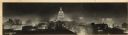
| Date: | 1940 |
|---|---|
| Description: | Panorama view, elevated, of the Wisconsin State Capitol at night from the roof of a building on Monona Avenue. The First National Bank and the Belmont Hote... |

| Date: | 1940 |
|---|---|
| Description: | Old farm home and present custodian's quarters at Kettle Moraine State Forest. |
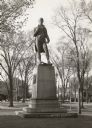
| Date: | 1940 |
|---|---|
| Description: | Statue created in honor of Robert Burns. Located in what is known as Burns Square, between Prospect & Farwell Avenues at Knapp Street. |
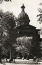
| Date: | 1940 |
|---|---|
| Description: | Front view of the courthouse, with several trees. People are sitting at various benches and tables in the space in front of the courthouse, and pigeons ar... |

| Date: | 1940 |
|---|---|
| Description: | Swimming area with children and adults enjoying the weather, with the Tower Hotel is in the background. |
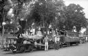
| Date: | 1940 |
|---|---|
| Description: | Two men and a police officer stand beside the "Pioneer," an early Chicago and Northwestern Railroad locomotive which is parked beside the Sauk County Court... |
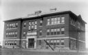
| Date: | 1940 |
|---|---|
| Description: | Exterior view of the Ondossagon Public School building. This three-story brick structure was built in 1917. |

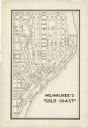
| Date: | 1940 |
|---|---|
| Description: | Map of Milwaukee County showing the metropolitan area, in yellow, and the proposed connecting of parkways and boulevards in green. The map also identifies ... |

| Date: | 1940 |
|---|---|
| Description: | Shows Milwaukee and Waukesha counties, and parts of Dodge, Washington, Ozaukee, Jefferson, Walworth, and Racine counties. Includes indexes of "Cities, Town... |
| Date: | 1940 |
|---|---|
| Description: | Photograph postcard of the park at the Grotto, with houses in the background. Caption reads: "Park at Grotto, Dickeyville, Wis." |

| Date: | 1940 |
|---|---|
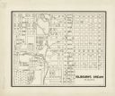
| Description: | This map hows block and lot numbers, water mains, roads, parks, the Sheboygan River and some landownership. |
| Date: | 1940 |
|---|---|
| Description: | This map is pen and ink on paper and is map 5 in a series of 12. The map shows streets, the Milwaukee River, Lake Michigan, and railroad tracks. |
| Date: | 1940 |
|---|---|
| Description: | This map is pen and ink on paper and is map 8 in a series of 12. The map shows streets and a railroad line. |

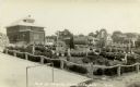
| Date: | 1940 |
|---|---|
| Description: | Text on front reads: "Billings Park, Superior, Wis." A city park on the St. Louis River, a freshwater estuary. Small islands with several bridges are surro... |
If you didn't find the material you searched for, our Library Reference Staff can help.
Call our reference desk at 608-264-6535 or email us at: