 Filter: Categories of Wisconsin Historical Images
Filter: FULL_DATE of 1941
Filter: Categories of Wisconsin Historical Images
Filter: FULL_DATE of 1941

| Date: | 1941 |
|---|---|
| Description: | Campaign poster in red, white and blue that reads: "Wisconsin needs a Governor. Elect! Loomis." Includes a head and shoulders portrait of Orland Steen Loom... |

| Date: | 1941 |
|---|---|
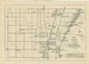
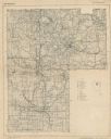
| Description: | Wisconsin counties, towns, cities, and selected villages, as well as the Menominee Indian Reservation are identified on this U.S. Bureau of the Census map ... |
| Date: | 1941 |
|---|---|
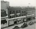
| Description: | Elevated view of the south side 200 block of State Street. A large sign announces the coming of a new Montgomery Ward's store on the site. Stores shown inc... |
| Date: | 1941 |
|---|---|
| Description: | A map shows early settlers by name and date, industries, the Chicago & North Western rail line, roads, and depths and net lines in Lake Michigan. Text prov... |

| Date: | 1941 |
|---|---|
| Description: | Mary Lee Griggs, head of Parent Education and director of the Play School at Neighborhood House, with Catherine Oliva, Delores Caire, and Sam Moskowsky. Th... |

| Date: | 1941 |
|---|---|
| Description: | A tourist map of Marinette County, Wisconsin that includes indexes of the lakes and rivers in the county which also identify the fish present, a list of ra... |

| Date: | 1941 |
|---|---|
| Description: | A pictorial map of Lake Mendota that shows Indian sites and legends associated with the Lake and its surrounding area. Some of those mentioned on the map i... |
| Date: | 1941 |
|---|---|
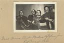
| Description: | Image from a scrapbook kept by Neighborhood House, with women from the Good Times Club holding up an afghan they made for the Red Cross. A group of women, ... |
| Date: | 1941 |
|---|---|
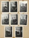
| Description: | Page from a scrapbook kept by Neighborhood House, with two views each of four women, each posing in a chair, casting a shadow on the wall behind her. |
| Date: | 1941 |
|---|---|
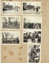
| Description: | Page from a scrapbook kept by Neighborhood House, with children crossing the street in front of the settlement house, gathering Easter eggs in the park, po... |

| Date: | 1941 |
|---|---|
| Description: | This 1941 tourist map of Washington Island, Wisconsin, shows points of interest and places of business. Some information is shown pictorially. Rock, Hog, D... |

| Date: | 1941 |
|---|---|
| Description: | This 1941 map covers Washburn County, Wisconsin, as well as western Sawyer, eastern Burnett, and northeastern Polk counties. It shows the locations of tour... |

| Date: | 1941 |
|---|---|
| Description: | This pictorial map shows sites related to Indian legends, mounds, and trails in the Chain O' Lakes region in southwestern Waupaca County, Wisconsin. |
| Date: | 1941 |
|---|---|
| Description: | This map covers the area of Lincoln and Oneida counties, and part of Marathon county and includes a location map and legend. The bottom left margin reads: ... |

| Date: | 1941 |
|---|---|
| Description: | A painted portrait of Walter Jodok Kohler completed after his death. |

| Date: | 1941 |
|---|---|
| Description: | Quarter-length portrait of Mrs. Laura Elston, wife of Henry Elston of Muscoda. |

| Date: | 1941 |
|---|---|
| Description: | Slightly elevated view of celebrants at an American Legion convention parade riding on a float made to represent Wisconsin fishing. |

| Date: | 1941 |
|---|---|
| Description: | A detail of a Sanborn map showing areas at Langdon and Henry Streets, including Lake Lawn Place. |

| Date: | 1941 |
|---|---|
| Description: | Elevated view of Sturgeon Bay in 1900. Sturgeon Bay Bridge spans the bay and several boats are on the water. A lighthouse sits on a small island in the bay... |
| Date: | 1941 |
|---|---|
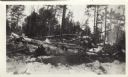
| Description: | This photograph of downed trees and branches is annotated, possibly by C.L. Harrington: "A fire hazard at this date Feb 28 '41. I have salvaged all or ab... |
If you didn't find the material you searched for, our Library Reference Staff can help.
Call our reference desk at 608-264-6535 or email us at: