Filter: Categories of Wisconsin Historical Images
Filter: FULL_DATE of 1950
Filter: Subject of human settlements
Filter: Categories of Wisconsin Historical Images
Filter: FULL_DATE of 1950
Filter: Subject of human settlements

| Date: | 1950 |
|---|---|
| Description: | Wheeler house with a porte cochere in the foreground. |
| Date: | 1950 |
|---|---|
| Description: | John Philbrick Webster House. Built in 1836, the building served as the federal land grant office and courthouse. The composer Joseph Philbrick Webster use... |
| Date: | 1950 |
|---|---|
| Description: | Downtown Ephraim from Peninsula State Park, directly across the bay. |
| Date: | 1950 |
|---|---|
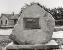
| Description: | "Pioneer Military Road - 1835 - Fort Howard, Greenbay - To Fort Crawford, Prairie Du Chien - Erected by Col. C.R. Pier Circle - Ladies of C.A.R. 1931." |
| Date: | 1950 |
|---|---|
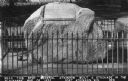
| Description: | Monument commemorating the place where General Atkinson built a stockade when he and his troops fought Black Hawk. Caption reads: "Near this spot General A... |
| Date: | 1950 |
|---|---|
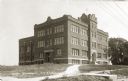
| Description: | View of the high school with several walkways leading up to it. Caption reads: "'High School,' Ft. Atkinson, Wis." |

| Date: | 1950 |
|---|---|
| Description: | Aerial view of the Madison isthmus looking north. Caption reads: "Madison Wisconsin — Between Lake Mendota and Lake Monona". |
| Date: | 1950 |
|---|---|
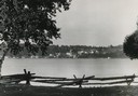
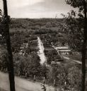
| Description: | View from hill through two trees over a road with a guard fence, overlooking the town laid out along a main thoroughfare. The area is heavily forested, and... |

| Date: | 1950 |
|---|---|
| Description: | Aerial view of fields near neighborhoods. |

| Date: | 1950 |
|---|---|
| Description: | Aerial view of the confluence of the Fox River and Green Bay. |

| Date: | 1950 |
|---|---|
| Description: | Aerial view of the Fox River, near Green Bay. Handwritten locations are marked, including: Site of First Court House, Little Rapids, De Pere. |

| Date: | 1950 |
|---|---|
| Description: | Aerial view of downtown and river. |
| Date: | 1950 |
|---|---|
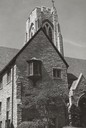
| Description: | Exterior view of Bethel Lutheran Church at 312 Wisconsin Avenue. |

| Date: | 1950 |
|---|---|
| Description: | Bethel Lutheran Church parish house and Sunday School, 10 West Johnson Street. |
| Date: | 1950 |
|---|---|
| Description: | Fort Howard Hospital. Within a year after the United States troops landed on the west bank of the Fox River in August, 1816. Dr. Beaumont lived in this hou... |
| Date: | 1950 |
|---|---|
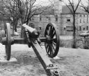
| Description: | A Civil War cannon captured at the Battle of Shiloh, displayed at Camp Randall near the corner of Randall Street and Dayton Street. A fire station is visib... |
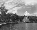
| Date: | 1950 |
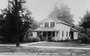
|---|---|
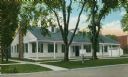
| Description: | Exterior view across water towrads the Roger Williams Inn. |
If you didn't find the material you searched for, our Library Reference Staff can help.
Call our reference desk at 608-264-6535 or email us at: