 Filter: Categories of Wisconsin Historical Images
Filter: FULL_DATE of 1952
Filter: County of Bayfield
Filter: Categories of Wisconsin Historical Images
Filter: FULL_DATE of 1952
Filter: County of Bayfield

| Date: | 1952 |
|---|---|
| Description: | This 1952 map of the northern parts of Bayfield and Douglas counties, Wisconsin, shows points established by E.T. Sweet in 1877, road points confirmed by S... |

| Date: | 1952 |
|---|---|
| Description: | This map of the northern parts of the Chequamegon Bay area in Bayfield and Ashland counties, Wisconsin, shows trails, roads, railroads, stations, the towns... |

| Date: | 1952 |
|---|---|
| Description: | The back and side of the main lodge at Forest Lodge on Lake Namakagon. The lodge was re-built in 1914-15 and remodeled in 1928-29. It is a single-story hor... |
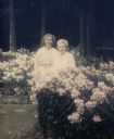
| Date: | 1952 |
|---|---|
| Description: | Mary Griggs and her daughter Mary are standing outside of the Forest Lodge guesthouse in a phlox flower garden. Both Marys are wearing white dresses. A co... |
If you didn't find the material you searched for, our Library Reference Staff can help.
Call our reference desk at 608-264-6535 or email us at: