 Filter: Categories of Wisconsin Historical Images
Filter: FULL_DATE of 1954
Filter: Subject of cities and towns
Filter: Type of Map or Atlas
Filter: Categories of Wisconsin Historical Images
Filter: FULL_DATE of 1954
Filter: Subject of cities and towns
Filter: Type of Map or Atlas

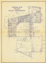
| Date: | 1954 |
|---|---|
| Description: | This map of Waukesha shows numbered ward boundaries, roads, and some buildings. The bottom of the map includes a street index. |
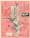
| Date: | 1954 |
|---|---|
| Description: | This map of Wausau is pink, red, gray, and white. The map includes indexes of streets, industries, and community buildings and features a photograph of the... |

| Date: | 1954 |
|---|---|
| Description: | This map of La Crosse shows residential, multiple dwelling, local business, commercial, light industrial, heavy industrial and special multiple dwelling la... |
| Date: | 1954 |
|---|---|
| Description: | This blue line print shows lot and block numbers and dimensions, additions, railroads, streets, and parks. |

| Date: | 1954 |
|---|---|
| Description: | This map shows the location of Catholic churches, missions, and shrines. The map is color coded and includes a key in the bottom left corner. The back of t... |
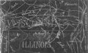
| Date: | 1954 |
|---|---|
| Description: | This photocopy map shows a early sketch of the settlement Southport. Rivers, lakes, other settlements, county boundaries, and roads are labeled. A portion ... |
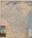
| Date: | 1954 |
|---|---|
| Description: | This map is designed to help Catholic tourists in Wisconsin find Catholic churches and missions. On the front side, a road map of Wisconsin showing the loc... |
If you didn't find the material you searched for, our Library Reference Staff can help.
Call our reference desk at 608-264-6535 or email us at: