 Filter: Categories of Wisconsin Historical Images
Filter: FULL_DATE of 1954
Filter: Subject of transportation
Filter: Subject of cities and towns
Filter: Creator Name of Unknown
Filter: Categories of Wisconsin Historical Images
Filter: FULL_DATE of 1954
Filter: Subject of transportation
Filter: Subject of cities and towns
Filter: Creator Name of Unknown
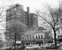
| Date: | 1954 |
|---|---|
| Description: | View from Capitol Square Park of the Belmont Hotel and nearby buildings. Includes the storefronts for Simpson's and Rennebohm Drug Store #6, at 19 North Pi... |
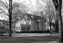
| Date: | 1954 |
|---|---|
| Description: | View across street towards a house on the corner in fall or early spring. Yawkey house was given by the A.P. Woodson family of Wausau to house the museum o... |
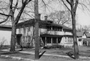
| Date: | 1954 |
|---|---|
| Description: | View of the Andrews house, the birthplace and home of Roy Chapman Andrews. |
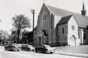
| Date: | 1954 |
|---|---|
| Description: | View from across street of church entrance along road. |

| Date: | 1954 |
|---|---|
| Description: | John Berry holds a baby as he poses with his wife Pearl. |
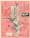
| Date: | 1954 |
|---|---|
| Description: | This map of Wausau is pink, red, gray, and white. The map includes indexes of streets, industries, and community buildings and features a photograph of the... |
If you didn't find the material you searched for, our Library Reference Staff can help.
Call our reference desk at 608-264-6535 or email us at: