 Filter: Categories of Wisconsin Historical Images
Filter: FULL_DATE of 1956
Filter: Subject of transportation
Filter: Creator Name of Newhouse, John
Filter: Categories of Wisconsin Historical Images
Filter: FULL_DATE of 1956
Filter: Subject of transportation
Filter: Creator Name of Newhouse, John

| Date: | 1956 |
|---|---|
| Description: | Aerial view of the South Park Street interchange. |

| Date: | 1956 |
|---|---|
| Description: | Aerial view of the Chicago, Milwaukee, and St. Paul Railroad station, roundhouse, and yard at the intersection of West Washington Avenue (across lower left... |

| Date: | 1956 |
|---|---|
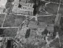
| Description: | Aerial view of lower University of Wisconsin-Madison campus with demolition of buildings on both sides of the Armory-Gymnasium to make space for future pla... |
| Date: | 1956 |
|---|---|
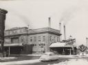
| Description: | View across intersection of the Chicago and Northwestern railroad station at Blair and Wilson Streets. Three tall chimneys from the MG&E plant can be seen ... |

| Date: | 1956 |
|---|---|
| Description: | Aerial view looking northeast from a point over the east end of Middleton, showing the west end of Lake Mendota (right mid-ground). Fox Bluff juts into the... |

| Date: | 1956 |
|---|---|
| Description: | Aerial view, looking eastward from a point several miles outside the southwestern limits of Madison in the direction of Verona. Crossing the image diagonal... |

| Date: | 1956 |
|---|---|
| Description: | Aerial view looking east along Madison's Lake Mendota shoreline. The large building under construction at center is Carroll Hall, a University of Wisconsin... |
| Date: | 1956 |
|---|---|
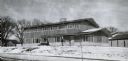
| Description: | A wintery view of the rectory of the Queen of Peace church lacated at 418 Holly Avenue. |

| Date: | 1956 |
|---|---|
| Description: | Aerial view of the Sears-Roebuck department store on East Washington Avenue and its surrounding parking lots. |

| Date: | 1956 |
|---|---|
| Description: | Aerial view over University Avenue of the University of Wisconsin-Madison campus, including University farm in the upper middle. The shoreline of Lake Mend... |
| Date: | 1956 |
|---|---|
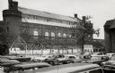
| Description: | View across parking lot of Armory (Red Gym or Old Red) on the University of Wisconsin-Madison campus. The gymnasium annex in course of demolition. There ... |
| Date: | 1956 |
|---|---|
| Description: | Aerial view of Birge and Bascom Halls (formerly Main Hall) on the University of Wisconsin-Madison campus. Birge Hall (foreground) with addition under cons... |

| Date: | 1956 |
|---|---|
| Description: | View down tree-lined sidewalk along Park Street towards University Avenue on the University of Wisconsin-Madison campus. Science Hall is on the right. |

| Date: | 1956 |
|---|---|
| Description: | Aerial view of Wisconsin General Hospital. |

| Date: | 1956 |
|---|---|
| Description: | The old YMCA building in the initial stage of demolition. |

| Date: | 1956 |
|---|---|
| Description: | Aerial view of Schenk's Corners where Atwood Avenue and Winnebago Street cross, looking north east. |

| Date: | 1956 |
|---|---|
| Description: | Aerial view of residential homes, farmland and streets. |
If you didn't find the material you searched for, our Library Reference Staff can help.
Call our reference desk at 608-264-6535 or email us at: