 Filter: Categories of Wisconsin Historical Images
Filter: FULL_DATE of 1960
Filter: Type of Map or Atlas
Filter: Subject of land
Filter: Categories of Wisconsin Historical Images
Filter: FULL_DATE of 1960
Filter: Type of Map or Atlas
Filter: Subject of land

| Date: | 1960 |
|---|---|
| Description: | This mid-20th century tourist brochure for Bayfield County, Wisconsin, includes a map of the county showing towns, cities and villages, highways and roads,... |

| Date: | 1960 |
|---|---|
| Description: | A hand-drawn map showing the "Negro Percentage of Each County's Population" in Mississippi. |

| Date: | 1960 |
|---|---|
| Description: | This map of Greedale shows local streets, parks, schools, and churches and includes manuscript annotations in green and blue showing tracts and parcels of ... |

| Date: | 1960 |
|---|---|
| Description: | This map shows a plat of the city, wards, lots, local streets, roads, railroads, buildings, parks, and part of Fox River. The map includes tables for plat ... |

| Date: | 1960 |
|---|---|
| Description: | This map shows lot and block numbers, additions, and rural acreages and includes an index of rail roads, industrial plants, Dunn County and Menominee owned... |
| Date: | 1960 |
|---|---|
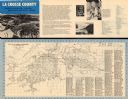
| Description: | This map is oriented with north to the right and includes an index of streets. The back of the map features text about La Crosse. |

| Date: | 1960 |
|---|---|
| Description: | This map is a cadastral map and shows block and lot numbers and dimensions, additions, streets, railroad, and Kiel Municipal Cemetery. The bottom right mar... |

| Date: | 1960 |
|---|---|
| Description: | This map shows local streets, wards, public buildings, parks, and part of the Fox River. The land is shown in white and the water is shown in blue. The map... |

| Date: | 1960 |
|---|---|
| Description: | This map shows lot numbers and dimensions, railroad, and streets. Fall Creek and Mill Pond (now Fall Creek Pond) are labeled. The map is a blue line print. |

| Date: | 1960 |
|---|---|
| Description: | This street map was likely given out by Mound City Bank and features a legend of points of interest and a street index. Streets are labeled as is the Round... |

| Date: | 1960 |
|---|---|
| Description: | This map shows block numbers, tract numbers, tract boundaries, city limits, local streets, railroads, Lake Mendota, and Lake Monona. |
| Date: | 1960 |
|---|---|
| Description: | This blue line print map shows lot and block numbers and dimensions, some landownership, roads, and railroads. The map includes manuscript annotations of a... |

| Date: | 1960 |
|---|---|
| Description: | This map includes a sheet index showing streets, proposed streets, the high school, and railroad. |
| Date: | 1960 |
|---|---|
| Description: | This map shows water mains, valves, hydrants, crosses, tees, and elevated tanks. The back of the map reads: "Notice of public hearing from T.H. Schuette, v... |

| Date: | 1960 |
|---|---|
| Description: | This blue line print map shows zone districts, lot and block numbers and dimensions, building setbacks, center lines of streets, and some landownership. Th... |

| Date: | 1960 |
|---|---|
| Description: | This map is a facsimile of a 1829 map and shows private land claims, landowners within military reserve boundaries, sawmill, Fort Howard, public barns, bri... |

| Date: | 1960 |
|---|---|
| Description: | This map shows uplands and swamps owned by the Goodman Lumber Division, water, and roads. The lower right corner includes a location map. The upper left co... |

| Date: | 1960 |
|---|---|
| Description: | This standard U.S.G.S. topographic map was annotated by civil engineer and railroad historian James P. Kaysen to show the location of existing and defunct ... |
If you didn't find the material you searched for, our Library Reference Staff can help.
Call our reference desk at 608-264-6535 or email us at: