Filter: Categories of Wisconsin Historical Images
Filter: FULL_DATE of 1967
Filter: Creator Name of Unknown
Filter: Subject of human settlements
Filter: Categories of Wisconsin Historical Images
Filter: FULL_DATE of 1967
Filter: Creator Name of Unknown
Filter: Subject of human settlements
| Date: | 1967 |
|---|---|
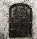
| Description: | Historical marker dedicated in 1922 on the site of a trading post. It was established in 1792 by Jacques Vieau as an agent of the Northwest Fur Company. Th... |
| Date: | 1967 |
|---|---|
| Description: | Pedestrians walking on the sidewalk along State Highway 21 & 73 in Wautoma. Parked automobiles and parking meters are also visible. |
| Date: | 1967 |
|---|---|
| Description: | On State Hightway 73 & 21, a two-story federal style building stands next to a Tastee-freeze that is for sale. |
| Date: | 1967 |
|---|---|
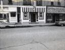
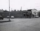
| Description: | A row of three storefronts along State Highway 21 & 73 in Wautoma, Wisconsin. One store front is clearly a bar; a second, whose original front has been gr... |
| Date: | 1967 |
|---|---|
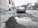
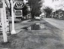
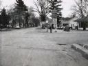
| Description: | A Wautoma, Wisconsin neighborhood. On both sides of the street in both the foreground and middle distance are service stations, beyond them is a residenti... |
| Date: | 1967 |
|---|---|
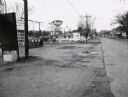
| Description: | A Standard Oil service station located on Oxford Street (State Highway 21&73) in Wautoma, Wisconsin. This photograph relates to the neighborhood view in 3... |
| Date: | 1967 |
|---|---|
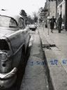
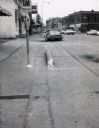
| Description: | Traffic on Oxford Street (State Highway 21&73), with a parking meter in the foreground and old storefronts in the distance. |
| Date: | 1967 |
|---|---|
| Description: | Deep Rock gasoline service station located at the intersection of Scott Street and Oxford Street (STH 21&73) in Wautoma, Wisconsin. |
| Date: | 1967 |
|---|---|
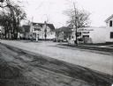
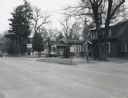
| Description: | Storefronts at the intersection of St. Marie Street and Oxford Street (STH 21&73) in Wautoma, Wisconsin. |
| Date: | 1967 |
|---|---|
| Description: | Zephyr gasoline station on STH 21&73 in Wautoma, Wisconsin. |

| Date: | 1967 |
|---|---|
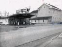
| Description: | Sinclair station located on STH 21, 22 & 73 in Wautoma, Wisconsin. |
| Date: | 1967 |
|---|---|
| Description: | Bungalow-style house located on STH 22, that had been converted into a beer garden and bait shop. |

| Date: | 1967 |
|---|---|
| Description: | Railroad Depot. North Freedom is the home of the Mid-Continent Railway Museum which operates excursion tours on a steam railroad. |
| Date: | 1967 |
|---|---|
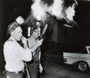
| Description: | Freedom House in flames after Milwaukee Police fired tear gas into the building. Two armed officers stand in front of the burning building. Both officers h... |
| Date: | 1967 |
|---|---|
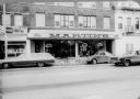
| Description: | The Deutschkron's store, Martin's, a tailor shop, located at 427 State Street (Ella's Deli on left). |

| Date: | 1967 |
|---|---|
| Description: | Father James Groppi (center) and the NAACP participate in a civil rights march. Police are armed and escorting the protestors. The marchers are passing an ... |

| Date: | 1967 |
|---|---|
| Description: | This tourist brochure for Bayfield County, Wisconsin, from 1967 includes a map of the county showing towns, cities and villages, highways and roads, railro... |

| Date: | 1967 |
|---|---|
| Description: | This map of Cedarburg includes a list of historic buildings in the left margin. The map was created by the Ozaukee County Historical Society for Cedarburg'... |
| Date: | 1967 |
|---|---|
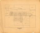
| Description: | This map is pen and pencil on paper and shows land ownership by name, blocks, lots, local streets, and railroads. To the right of the title the map reads: ... |
If you didn't find the material you searched for, our Library Reference Staff can help.
Call our reference desk at 608-264-6535 or email us at: