 Filter: Categories of Wisconsin Historical Images
Filter: FULL_DATE of 1973
Filter: Subject of schools
Filter: Categories of Wisconsin Historical Images
Filter: FULL_DATE of 1973
Filter: Subject of schools

| Date: | 1973 |
|---|---|
| Description: | This map includes an index of streets and schools and also shows parks, schools and public lands, and industrial sites. Portions of the map are in green an... |
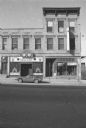
| Date: | 1973 |
|---|---|
| Description: | View across King Street towards The Gallery Inn restaurant, on the left, and the Buy Sell shop with a show window on the corner of King and Webster streets... |
If you didn't find the material you searched for, our Library Reference Staff can help.
Call our reference desk at 608-264-6535 or email us at: