 Filter: Categories of Wisconsin Historical Images
Filter: FULL_DATE of 1976
Filter: County of Milwaukee
Filter: Type of Map or Atlas
Filter: Categories of Wisconsin Historical Images
Filter: FULL_DATE of 1976
Filter: County of Milwaukee
Filter: Type of Map or Atlas

| Date: | 1976 |
|---|---|
| Description: | An 1876 reprinted map of the Township of Franklin, Milwaukee County, Wisconsin, that shows the land ownership and sectioning of the town, as well as the ro... |

| Date: | 1976 |
|---|---|
| Description: | A street map of Milwaukee County, Wisconsin that identifies the location of schools, hospitals, parks, beaches, streets, freeways, both planned or under co... |
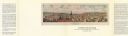
| Date: | 1976 |
|---|---|
| Description: | Bird’s-eye-view map. Contains labeled points of interest below the map describing the buildings and streets. Caption below the map reads: "CITIES ON STONE ... |
If you didn't find the material you searched for, our Library Reference Staff can help.
Call our reference desk at 608-264-6535 or email us at: