 Filter: Categories of Wisconsin Historical Images
Filter: Subject of Aerial photographs
Filter: Year of 1900-1999
Filter: Community of Milwaukee
Filter: Categories of Wisconsin Historical Images
Filter: Subject of Aerial photographs
Filter: Year of 1900-1999
Filter: Community of Milwaukee

| Date: | 1964 |
|---|---|
| Description: | Aerial view of the Milwaukee County Zoo grounds nearing its completion. |
| Date: | 03 09 1965 |
|---|---|
| Description: | Aerial view and illustration of projected projects, including interstates and interchanges in downtown Milwaukee, for the 1970's. |

| Date: | 1975 |
|---|---|
| Description: | Aerial view of Milwaukee County Stadium and the intersection of US 41 and I-94. County Stadium was built in 1953 and demolished in 2001. Although undated... |

| Date: | 1965 |
|---|---|
| Description: | Aerial view of early construction at the Marquette Interchange in Milwaukee, the junction of Interstate Highways I94 and I43. Construction began in 1964, ... |

| Date: | 04 01 1975 |
|---|---|
| Description: | The bridge over the Milwaukee Harbor named in honor of former Mayor Daniel Hoan. The bridge was constructed between 1970 and 1972, but during the period de... |

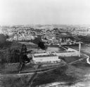
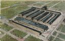
| Date: | 1931 |
|---|---|
| Description: | An aerial view of the Milwaukee Works grounds that includes numerous large factory buildings, railways and smaller office buildings. |
| Date: | 01 1973 |
|---|---|
| Description: | Aerial view of the Falk Corporation. Falk caption reads, "Black and white negatives, furnished to advertising department by J. Blank. See similar color pic... |
| Date: | 08 1975 |
|---|---|
| Description: | Original Falk description reads, "Latest aerial views of the main plant taken by Robert McCoy." |

| Date: | 10 30 1990 |
|---|---|
| Description: | Original Falk caption reads, "Aerial view [of] main plant (October 1990)." |

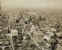
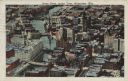
| Date: | 1955 |
|---|---|
| Description: | Aerial view of downtown, including railroad tracks in foreground. |

| Date: | 1951 |
|---|---|
| Description: | Aerial view of Jones Island and garbage disposal plant. |

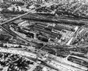
| Date: | 1950 |
|---|---|
| Description: | Harbor area of Jones Island and garbage disposal plant, Stratton Grain Co., and more. |

| Date: | 1950 |
|---|---|
| Description: | Divided highway is South Chase Avenue between West Lincoln Avenue (2300) and East Oklahoma Avenue (3100). |
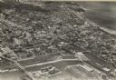
| Date: | 1930 |
|---|---|
| Description: | Aerial view of downtown area including churches, homes, and large buildings, stretching to the horizon. |
| Date: | 1938 |
|---|---|
| Description: | Aerial view of rivers, with Lake Michigan in upper right, train yards, and highway in lower left. |

| Date: | 1922 |
|---|---|
| Description: | Aerial view of downtown with City Hall and Milwaukee River. |
| Date: | 1940 |
|---|---|
| Description: | Aerial view of courthouse in center foreground with snow on the ground. |

| Date: | 1947 |
|---|---|
| Description: | City Hall near the Milwaukee River. |
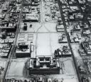
| Date: | 1925 |
|---|---|
| Description: | Downtown aerial view with the Milwaukee River and City Hall. Caption reads: "Downtown Aerial View, Milwaukee, Wis." |
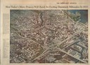
| Date: | 1910 |
|---|---|
| Description: | Aerial view of the factory surrounded by fields, roads, and several houses, as well as the railroad tracks that go around the building. Caption reads: "Wes... |
If you didn't find the material you searched for, our Library Reference Staff can help.
Call our reference desk at 608-264-6535 or email us at: