 Filter: Categories of Wisconsin Historical Images
Filter: Subject of Aerial photographs
Filter: Year of 1900-1999
Filter: Year of 1930-1939
Filter: Categories of Wisconsin Historical Images
Filter: Subject of Aerial photographs
Filter: Year of 1900-1999
Filter: Year of 1930-1939

| Date: | 01 1934 |
|---|---|
| Description: | Aerial view of New Butler, in Waukesha County. |
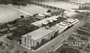
| Date: | 1931 |
|---|---|
| Description: | Aerial view of International Harvester's Rock Falls Works. The factory was owned by the Keystone Manufacturing Company until 1904, when the company was pur... |
| Date: | 01 1934 |
|---|---|
| Description: | An aerial view of the Oshkosh Airport about three years after Steve Wittman became the manager. The field was established in 1928 by Oshkosh Airport, Inc.... |
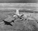
| Date: | 1939 |
|---|---|
| Description: | Aerial view of a B-15 flying over the granite memorial to the Wright Brothers' first flight at Kitty Hawk, North Carolina. The 60-foot memorial was dedicat... |
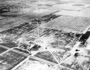
| Date: | 12 14 1931 |
|---|---|
| Description: | Aerial view of Madison industrial district taken from the top of the Madison Gas and Electric Co. gas tank looking south west down the 600 and 700 blocks o... |
| Date: | 04 09 1931 |
|---|---|
| Description: | Aerial view of Lake Delton airport. |

| Date: | 08 20 1930 |
|---|---|
| Description: | Aerial view of the Madison skyline from University of Wisconsin Field House, overlooking the Wisconsin State Capitol and, in the foreground, Gateway Lumber... |
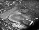
| Date: | 1934 |
|---|---|
| Description: | Aerial view of Camp Randall Stadium and Field House on the University of Wisconsin-Madison campus. |

| Date: | 1930 |
|---|---|
| Description: | Aerial view of the city and the river. |

| Date: | 1930 |
|---|---|
| Description: | Aerial view of Carson Park, Half Moon Lake and part of the West Side in the foreground. The municipal bath house is on the lake shore in the foreground. A ... |

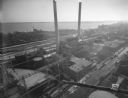
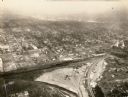
| Date: | 1930 |
|---|---|
| Description: | Aerial view of city, with Eau Claire River is in the foreground with Milwaukee railroad bridge at left. Gillette Rubber Co. plant is in center with Omaha r... |

| Date: | 1931 |
|---|---|
| Description: | Aerial view looking north, with a small portion of the West Side (left), nearly all of the North Side and part of the business district of the East Side. A... |

| Date: | 1934 |
|---|---|
| Description: | Aerial view of Capitol and Lake Mendota and Lake Monona. |

| Date: | 1930 |
|---|---|
| Description: | Aerial view above Shorewood Hills near Madison, looking northeast. |

| Date: | 1930 |
|---|---|
| Description: | Aerial view of isthmus looking east toward Lake Mendota and the Wisconsin State Capitol, with Lake Monona and the horizon in the background. |

| Date: | 07 06 1937 |
|---|---|
| Description: | Aerial view of the west central part of isthmus and the University of Wisconsin campus. |
| Date: | 1934 |
|---|---|
| Description: | Aerial view of Janesville showing the river fill for the new sewerage disposal plant. |
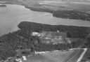
| Date: | 1930 |
|---|---|
| Description: | Aerial view of Turville Point and Turville farm, Lake Monona. |
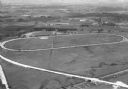
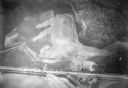
| Date: | 1930 |
|---|---|
| Description: | Aerial view of the Dane County fairgrounds, including several buildings and a track. |
If you didn't find the material you searched for, our Library Reference Staff can help.
Call our reference desk at 608-264-6535 or email us at:
