 Filter: Categories of Wisconsin Historical Images
Filter: Subject of Agriculture
Filter: Type of Map or Atlas
Filter: Subject of human settlements
Filter: Categories of Wisconsin Historical Images
Filter: Subject of Agriculture
Filter: Type of Map or Atlas
Filter: Subject of human settlements

| Date: | 1874 |
|---|---|
| Description: | Bird's-eye map of Chippewa Falls. |

| Date: | 1878 |
|---|---|
| Description: | Bird's-eye map of Kewaskum. Includes a list of hotels, churches, post office, railroad depot, etc. |

| Date: | 1881 |
|---|---|
| Description: | Bird's-eye map of Milton Junction. |

| Date: | 1883 |
|---|---|
| Description: | Bird's-eye map of Sauk City. |

| Date: | 1879 |
|---|---|
| Description: | Bird's-eye view of Viroqua, county seat of Vernon County. |

| Date: | 1871 |
|---|---|
| Description: | Like many southeastern Wisconsin villages, Edgerton was settled by Yankee immigrants in the 1830s. Though this view gives no indication of it, by 1871 toba... |
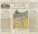
| Date: | 1922 |
|---|---|
| Description: | Wisconsin Geological and Natural History Survey soil map of Wisconsin supplemented by promotional materials about the County's prospects, schools and agric... |

| Date: | 1878 |
|---|---|
| Description: | Map reads: "The P.P. Mast & Co's New Map of Wisconsin, Minnesota, and Northern Iowa". There are various advertisements for P.P. Mast & Co's broad-cast seed... |

| Date: | 1855 |
|---|---|
| Description: | Map reads "Our Country" which is accompanied by a sailor with a flag to the left and workers rejoicing under the Constitution and Laws to the right. Across... |

| Date: | 1935 |
|---|---|
| Description: | This map shows in different colors virgin timberland, second growth timber, pasture belt, crop-pasture belt, intensive crop-pasture belt, intensive pasture... |

| Date: | 1914 |
|---|---|
| Description: | A hand-colored map of Wisconsin showing the locations of cities and towns, counties, railway lines, the steamship lines in Lake Superior and lake Michigan.... |

| Date: | 1872 |
|---|---|
| Description: | This map, which includes eastern Iowa, northern Illinois and a portion of Michigan's Upper peninsula, shows the township survey grid and identifies countie... |

| Date: | 1902 |
|---|---|
| Description: | This map shows the railroads of southern Wisconsin with the routes of the Chicago, Milwaukee, and St. Paul Railway traced in red. The township grid, counti... |

| Date: | 1906 |
|---|---|
| Description: | A hand-colored commercial map of Wisconsin and portions of eastern Minnesota, Iowa, northern Illinois, and the Michigan’s Upper Peninsula. The map shows ra... |

| Date: | 1906 |
|---|---|
| Description: | A commercial map of Wisconsin showing the location of creameries and cheese factories in the state. In the lower portion of the map provides the number of ... |

| Date: | 1908 |
|---|---|
| Description: | A map of Langlade County, Wisconsin that shows the townships and ranges, towns, cities and villages, wagon roads, churches, schools, lakes, rivers, railroa... |

| Date: | 1947 |
|---|---|
| Description: | A map of Manitowoc County that shows the location and dates of seven pig fairs in the county; it also lists monthly pig and cattle sales in the surrounding... |

| Date: | 1911 |
|---|---|
| Description: | This 1911 map of south central Sawyer County, Wisconsin, shows land for sale by Veness & Kasl of Exeland, the township and range system, sections, homes, r... |

| Date: | 1914 |
|---|---|
| Description: | This early 20th century map shows the township and range system, sections, railroads, roads, lakes, wetlands, and streams in the western Sawyer County town... |
If you didn't find the material you searched for, our Library Reference Staff can help.
Call our reference desk at 608-264-6535 or email us at:
