 Filter: Categories of Wisconsin Historical Images
Filter: Subject of Agriculture
Filter: County of Sauk
Filter: Subject of water
Filter: Categories of Wisconsin Historical Images
Filter: Subject of Agriculture
Filter: County of Sauk
Filter: Subject of water

| Date: | 1883 |
|---|---|
| Description: | Bird's-eye map of Sauk City. |
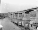
| Date: | 1922 |
|---|---|
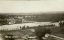
| Description: | Elevated view of bridge over Wisconsin River built in 1921 to take the place of the old wooden bridge when it became condemned. Caption reads: "Prairie Du ... |
| Date: | 1925 |
|---|---|
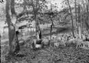
| Description: | A shepherd with a crook watches his flock in a wooded area beside a pond. His sheep dog rests beside him. |
| Date: | 1925 |
|---|---|
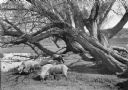
| Description: | A flock of sheep graze under old willow trees alongside a stream. |
| Date: | 1925 |
|---|---|
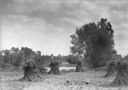
| Description: | Corn shocks stand in a field with several pumpkins on the ground. There is a stream or river along the field, and in the background is a bridge over a dam... |
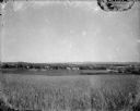
| Date: | 1920 |
|---|---|
| Description: | A view of a rolling rural landscape, most likely in Sauk County. In the far distance are houses and farm buildings, a church and a larger building, center ... |

| Date: | 1925 |
|---|---|
| Description: | Two large clay block silos stand beside a river. There is a large building, possibly a mill, behind the silos, a barn to the right and a shed on the left. ... |
| Date: | 1936 |
|---|---|
| Description: | Elevated view of the power dam on the Wisconsin River at Prairie du Sac. |
| Date: | 1922 |
|---|---|
| Description: | View from shoreline of bridge over the Wisconsin River. In the left lower foreground is a shed, and a rowboat. On the opposite shoreline are farms and fiel... |

| Date: | 1925 |
|---|---|
| Description: | View from bluff of Crystal Lake and surrounding rolling hills. There is a dairy farm in the foreground at the bottom of the bluff. Cows are grazing in fiel... |
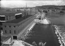
| Date: | 1922 |
|---|---|
| Description: | Elevated view of the power plant and dam on the Wisconsin River. Two workers are walking near the center. On the opposite shoreline are fields and tree-cov... |
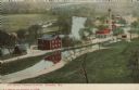
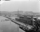
| Date: | 1908 |
|---|---|
| Description: | Colorized postcard with an elevated view of the pumping station. On the left is a bridge over the river, and buildings on a strip of land between the river... |

| Date: | 1975 |
|---|---|
| Description: | This map shows plat of the city, city limits, local streets, and part of Baraboo River. The map includes 2 inset maps and a legend showing residential, bus... |
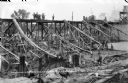
| Date: | |
|---|---|
| Description: | Elevated view of workers putting in concrete to create an apron for the power dam they're building. Two men in suits are standing on a platform on the far ... |

| Date: | |
|---|---|
| Description: | Stereograph of an elevated view of Devil's Lake and the valley to the southeast. The valley may be the site of the old campground that has been moved farth... |
If you didn't find the material you searched for, our Library Reference Staff can help.
Call our reference desk at 608-264-6535 or email us at: