 Filter: Categories of Wisconsin Historical Images
Filter: Subject of Animals
Filter: Subject of men
Filter: Subject of harbors
Filter: Categories of Wisconsin Historical Images
Filter: Subject of Animals
Filter: Subject of men
Filter: Subject of harbors
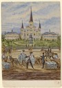
| Date: | 1859 |
|---|---|
| Description: | On an excursion to the South in November 1859, Hölzlhuber made the three-day trip on the steamboat Planet from St. Louis to New Orleans. In the harb... |
| Date: | 1899 |
|---|---|
| Description: | A man in work clothes is operating a horse-drawn mower in a patch of grass along a waterfront, while another man wearing a hat and tie is looking on. Ships... |
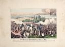
| Date: | |
|---|---|
| Description: | A large color lithograph with caption of the battle in progress. |

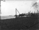
| Date: | 1915 |
|---|---|
| Description: | Boats unloading at Standard Oil Co.'s pier, with a horse, wagon, and a number of men handling lumber and other building materials. |

| Date: | 1968 |
|---|---|
| Description: | View of Manhattan from the Staten Island Ferry, with a couple standing in the foreground. The woman is wearing a leopard print coat, and seagulls wheel in ... |
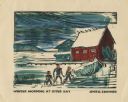
| Date: | 1949 |
|---|---|
| Description: | Holiday card of the Sister Bay lakeshore. Three figures are on the shore. Two boathouses, a covered boat, a pier, and two upright boats are in the backgrou... |
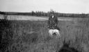
| Date: | 1923 |
|---|---|
| Description: | A well-dressed man poses holding a German short-haired pointer on a leash near the outlet of the Fish Creek into the harbor. |

| Date: | 05 1973 |
|---|---|
| Description: | Steve Hopkins and Roger Debenham posing in Sturgeon Bay with seven trout they caught on Lake Michigan hanging from pegs under a sign that reads, "Bay Chart... |

| Date: | 1715 |
|---|---|
| Description: | One of Herman Moll's most famous maps, often referred to as The Codfish Map, it shows rivers and portages, cities, Indian villages, wind directions, routes... |

| Date: | 1733 |
|---|---|
| Description: | This map of North America shows settlements, rivers, lakes, Native American land, trade winds, and numerous topographical features such as forests and moun... |
If you didn't find the material you searched for, our Library Reference Staff can help.
Call our reference desk at 608-264-6535 or email us at:
