 Filter: Categories of Wisconsin Historical Images
Filter: Subject of Archaeological sites
Filter: Subject of cities and towns
Filter: Subject of indians of north america
Filter: Categories of Wisconsin Historical Images
Filter: Subject of Archaeological sites
Filter: Subject of cities and towns
Filter: Subject of indians of north america
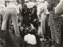
| Date: | 1935 |
|---|---|
| Description: | Members of the Wisconsin Outing Club watch the excavation of a burial mound at the Outlet group in 1935. |

| Date: | 1791 |
|---|---|
| Description: | Small map of an abandoned Native American town and fort at the junction of the Ohio and Muskingum River. It shows the fortifications, an outline of the tow... |

| Date: | 1924 |
|---|---|
| Description: | A map of the Madison Township, T7N R9E including Lake Mendota showing the location of Ho Chunk encampments and effigy mounds. |
If you didn't find the material you searched for, our Library Reference Staff can help.
Call our reference desk at 608-264-6535 or email us at: