Filter: Categories of Wisconsin Historical Images
Filter: Subject of Archaeological sites
Filter: Subject of cities and towns
Filter: Categories of Wisconsin Historical Images
Filter: Subject of Archaeological sites
Filter: Subject of cities and towns
| Date: | |
|---|---|
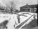
| Description: | A turtle effigy mound on the University of Wisconsin-Madison campus, outlined by melting snow. |
| Date: | 1920 |
|---|---|
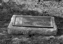
| Description: | Historic site marker to commemorate Man Mound and to mark Man Mound Park. The inscription reads "Man Mound Park. Mound located and platted by W.H. Canfield... |

| Date: | 1890 |
|---|---|
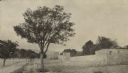
| Description: | Mound known as the Hill of the Dead. |

| Date: | 1953 |
|---|---|
| Description: | Replica of Eleazer William's log cabin, with an archeological dig being conducted in front of the cabin. |
| Date: | 1910 |
|---|---|
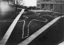
| Description: | Elevated view of a double-tailed turtle effigy mound on Observatory Hill on the University of Wisconsin-Madison campus. |

| Date: | 1935 |
|---|---|
| Description: | Members of the Wisconsin Outing Club watch the excavation of a burial mound at the Outlet group in 1935. |

| Date: | 1898 |
|---|---|
| Description: | This 1896 map of the Chain-O-Lakes region of Waupaca County, Wisconsin, shows the lakes and streams, some topography, archaeological sites, roads, railroad... |
| Date: | 1929 |
|---|---|
| Description: | Outside the walls of Tebessa, in north eastern Algeria. Hills are in the far background. |

| Date: | 01 1969 |
|---|---|
| Description: | A map of Oneida county, which includes a small drawing of a hodag. |

| Date: | 1791 |
|---|---|
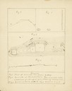
| Description: | Small map of an abandoned Native American town and fort at the junction of the Ohio and Muskingum River. It shows the fortifications, an outline of the tow... |
| Date: | 11 15 1925 |
|---|---|
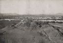
| Description: | View of the tomb of Queen Tin Hinan from the south. Three people are standing on top of the tomb. Mountains and the city of El Oued can be seen in the back... |

| Date: | 1924 |
|---|---|
| Description: | A map of the Madison Township, T7N R9E including Lake Mendota showing the location of Ho Chunk encampments and effigy mounds. |
If you didn't find the material you searched for, our Library Reference Staff can help.
Call our reference desk at 608-264-6535 or email us at: