 Filter: Categories of Wisconsin Historical Images
Filter: Subject of Archaeological sites
Filter: Subject of transportation
Filter: Categories of Wisconsin Historical Images
Filter: Subject of Archaeological sites
Filter: Subject of transportation
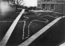
| Date: | 1910 |
|---|---|
| Description: | Elevated view of a double-tailed turtle effigy mound on Observatory Hill on the University of Wisconsin-Madison campus. |

| Date: | 1898 |
|---|---|
| Description: | This 1896 map of the Chain-O-Lakes region of Waupaca County, Wisconsin, shows the lakes and streams, some topography, archaeological sites, roads, railroad... |

| Date: | 1930 |
|---|---|
| Description: | The remains of an arch surrounded by tumbled stones and ruins of an archaeological site. A dirt track in the foreground goes through the arch and rises to ... |

| Date: | 05 1930 |
|---|---|
| Description: | Camp Pond in North Africa. A rock in the fire pit in the foreground has "Camp Pond" painted on it. Three tents, three people, two upside down bicycles and ... |

| Date: | 1930 |
|---|---|
| Description: | The camp at El Kantara, Algeria. In the foreground, members of the expedition are sleeping on pallets, under blankets. Just beyond the sleepers are two tru... |

| Date: | 1930 |
|---|---|
| Description: | A woman is working on a Remington typewriter, set on a table with a patterned tablecloth, on the last day in camp. One man is standing in the center, and t... |

| Date: | 06 1930 |
|---|---|
| Description: | A woman is recording the contents of each box on a Remington typewriter, set on a table with a patterned tablecloth, on the last day in camp. Three men are... |

| Date: | 1927 |
|---|---|
| Description: | Workmen excavate at an archaeological site at Mechta. M. Bebruge is the man in the foreground. A man sitting on the ground in the background on the right i... |

| Date: | 11 12 1926 |
|---|---|
| Description: | Alonzo Pond and colleague, M. Debruge, posing for a photograph at Mechta. M. Debruge has a cigarette in a holder in his hand, and both men are wearing coat... |
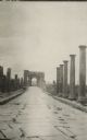
| Date: | 1929 |
|---|---|
| Description: | Chariot wheel ruts can still be seen in Timgad, the ruins of an ancient Roman colonial town in north eastern Algeria. Columns are along both sides of the s... |
| Date: | 1929 |
|---|---|
| Description: | Outside the walls of Tebessa, in north eastern Algeria. Hills are in the far background. |

| Date: | 1929 |
|---|---|
| Description: | The Pond camp at Medfoun, early in the morning. A tent surrounded by camp furniture and supplies is in the center. A truck is parked beside the tent on the... |

| Date: | 01 1969 |
|---|---|
| Description: | A map of Oneida county, which includes a small drawing of a hodag. |

| Date: | 1930 |
|---|---|
| Description: | A map of the site of a Native American village with a complex of linear raised garden beds and cache pits near Leeman. Also shown are a farmstead, road, an... |

| Date: | 1924 |
|---|---|
| Description: | A map of the Madison Township, T7N R9E including Lake Mendota showing the location of Ho Chunk encampments and effigy mounds. |
If you didn't find the material you searched for, our Library Reference Staff can help.
Call our reference desk at 608-264-6535 or email us at: