 Filter: Categories of Wisconsin Historical Images
Filter: Subject of Associations, institutions, etc.
Filter: Type of Map or Atlas
Filter: Subject of land
Filter: Categories of Wisconsin Historical Images
Filter: Subject of Associations, institutions, etc.
Filter: Type of Map or Atlas
Filter: Subject of land

| Date: | 1910 |
|---|---|
| Description: | This early 20th-century map of Wisconsin counties indicates indicate the Wisconsin counties in which there are county historical societies auxiliary to the... |

| Date: | 1923 |
|---|---|
| Description: | This map from the Wisconsin Lakes and Parks Association shows the area of a proposed state park, much of which is now part of the Flambeau River State Fore... |

| Date: | 1925 |
|---|---|
| Description: | This 1925 map of the northern portion of Sawyer County, Wisconsin, shows the township and range system, sections, roads, railroads, and lakes and streams i... |

| Date: | 1847 |
|---|---|
| Description: | Shows parts of northeastern Iowa County, northwestern Dane County, and the extreme southern part of Sauk County "shewing the position of the British Temper... |

| Date: | 1915 |
|---|---|
| Description: | Shows land ownership, roads, railroads, and highways. Includes significant manuscript annotations and table of Wisconsin Highway Commission members. "The r... |

| Date: | 1956 |
|---|---|
| Description: | Map reads: "TAX EXEMPT LAND in the CITY OF MADISON". There is a legend of "Government Land" represented in stripes, "Religious and Fraternal Organization" ... |
| Date: | 1902 |
|---|---|
| Description: | A map of Lake Geneva and Lake Delavan, also including Lake Como. |
| Date: | 1907 |
|---|---|
| Description: | A map of Lake Geneva and Lake Delavan, including Lake Como. |

| Date: | 1908 |
|---|---|
| Description: | A detail of a Sanborn map showing the North Blair Street area. |

| Date: | 04 1905 |
|---|---|
| Description: | Map of the Madison, Wisconsin region showing the four major lakes, starting in the north with Lake Mendota, Lake Monona, Lake Waubesa, and Lake Kegonsa. La... |

| Date: | 1948 |
|---|---|
| Description: | This illustrated map shows major westward trails from 1785 to 1866: Old Oregon Trail and its deviations, Old Spanish Trail, Lewis and Clark route, Santa Fe... |

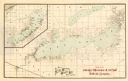
| Date: | 1891 |
|---|---|
| Description: | This map shows soft marshland, water channels, solid ground, club boundary and shooting boxes. Big Lake, First Channel, Second Channel, Fout Mile Pond, Mal... |

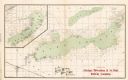
| Date: | 1891 |
|---|---|
| Description: | This map shows soft marshland, water channels, solid ground, club boundary and shooting boxes. Big Lake, First Channel, Second Channel, Fout Mile Pond, Mal... |
If you didn't find the material you searched for, our Library Reference Staff can help.
Call our reference desk at 608-264-6535 or email us at: