 Filter: Categories of Wisconsin Historical Images
Filter: Subject of Attractions
Filter: Subject of boats and boating
Filter: Categories of Wisconsin Historical Images
Filter: Subject of Attractions
Filter: Subject of boats and boating
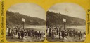
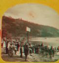
| Date: | 1877 |
|---|---|
| Description: | "The Grand Regatta, at Devil's Lake, June 21st & 22nd, 1877." A stereograph showing spectators gathered behind the starter's cannon on Devil's Lake. |
| Date: | |
|---|---|
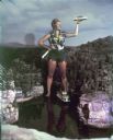
| Description: | Woman dressed as Paulina Bunyan (female version of Paul Bunyan) standing in the Minirama recreation of the Wisconsin Dells. She holds an axe in one hand an... |
| Date: | |
|---|---|
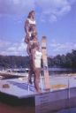
| Description: | Four female water skiers posed in profile in white bathing suits on a pier or floating raft. Three stand on a ladder so they appear in a vertical column. O... |
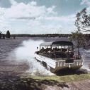
| Date: | 1965 |
|---|---|
| Description: | Amphibious vehicle known as a Duck splashes into Lake Delton as it carries passengers on a tour of the Wisconsin Dells. |
| Date: | |
|---|---|
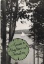
| Description: | Cover of A guide to Kraftwood Gardens showing a view of a sailboat on Lake Machkinosiew (now Enterprise Lake) seen between trees. The publication's ... |
| Date: | 1887 |
|---|---|
| Description: | "The Grand Regatta, at Devil's Lake, June 21st & 22nd, 1877." A stereograph showing spectators gathered behind the starter's cannon on Devil's Lake. |

| Date: | 1966 |
|---|---|
| Description: | This colored road map shows automobile roads in Wisconsin as well as portions of nearby states. A map key indicates relative sizes of cities and towns. On ... |

| Date: | 1970 |
|---|---|
| Description: | This colored map displays a brief description of tourist attractions in the state, as well as a grid of state parks and recreational facilities. There is a... |

| Date: | 1966 |
|---|---|
| Description: | This colored road map shows automobile roads in Wisconsin as well as portions of nearby states. Information on the quality and type of any road shown (inte... |

| Date: | 1971 |
|---|---|
| Description: | This colored map displays Wisconsin and bordering areas of Iowa, Minnesota, and Michigan. There is color-coding on the map to indicate National Forests, an... |

| Date: | 1973 |
|---|---|
| Description: | This colored map displays Wisconsin and bordering areas of Iowa, Minnesota, and Michigan. There is color-coding on the map to indicate National Forests, a... |

| Date: | 1975 |
|---|---|
| Description: | This colored road map of Wisconsin displays "Featured Points of Interest" and "Historical Points of Interest" in the state, including three color photograp... |

| Date: | 1973 |
|---|---|
| Description: | This map displays, in color, Wisconsin and bordering areas of Iowa, Minnesota, Illinois, and Michigan. At the bottom is a map key indicating road classifi... |

| Date: | 1976 |
|---|---|
| Description: | This color map displays Wisconsin and bordering areas of Iowa, Minnesota, Illinois, and Michigan. At the bottom is a map key indicating road classification... |

| Date: | 1976 |
|---|---|
| Description: | This colored map displays Wisconsin and portions of bordering states, including a detailed map of the Wisconsin Dells area. Surrounding the map are multipl... |

| Date: | 1977 |
|---|---|
| Description: | This colored map displays Wisconsin and portions of bordering states, including a detailed map of the Wisconsin Dells area. Surrounding the map are multipl... |

| Date: | 1962 |
|---|---|
| Description: | This colored map represents "Tour #2" of a series of driving tours of the state published by the Sperry & Hutchinson Company, in order to "help you enjoy W... |

| Date: | 1962 |
|---|---|
| Description: | This colored map represents "Tour #1" of a series of driving tours of the state published by the Sperry & Hutchinson Company, in order to "help you enjoy W... |

| Date: | 1949 |
|---|---|
| Description: | This multi-colored promotional map for recreational activities in the Hayward area includes a graphic of distances from Midwestern cities to Hayward, with ... |
If you didn't find the material you searched for, our Library Reference Staff can help.
Call our reference desk at 608-264-6535 or email us at:
