 Filter: Categories of Wisconsin Historical Images
Filter: Subject of Attractions
Filter: Subject of recreation areas
Filter: Categories of Wisconsin Historical Images
Filter: Subject of Attractions
Filter: Subject of recreation areas
| Date: | |
|---|---|
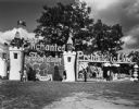
| Description: | Entrance to Enchanted Forest and Prehistoric Land. |
| Date: | |
|---|---|
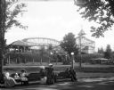
| Description: | People gather around a bench in front of Casino Amusement Park. A roller coaster, pavilion, and ticket booth stand behind them. |
| Date: | |
|---|---|
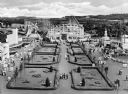
| Description: | View of the Coney Island Amusement Park featuring a large garden and lawn, a roller coaster, a windmill, several buildings and amusements, and crowds of pe... |
| Date: | |
|---|---|
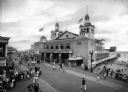
| Description: | Crowds walk along the boardwalk at Funchase amusement pier. A building with flags flying from its turrets features a sign that reads "Funchase Skating". T... |

| Date: | |
|---|---|
| Description: | Historical marker identifying the location of the first house in Wisconsin built between Washburn and Ashland in 1658. |

| Date: | 1966 |
|---|---|
| Description: | This colored road map shows automobile roads in Wisconsin as well as portions of nearby states. A map key indicates relative sizes of cities and towns. On ... |

| Date: | 1970 |
|---|---|
| Description: | This colored map displays a brief description of tourist attractions in the state, as well as a grid of state parks and recreational facilities. There is a... |

| Date: | 1966 |
|---|---|
| Description: | This colored road map shows automobile roads in Wisconsin as well as portions of nearby states. Information on the quality and type of any road shown (inte... |

| Date: | 1971 |
|---|---|
| Description: | This colored map displays Wisconsin and bordering areas of Iowa, Minnesota, and Michigan. There is color-coding on the map to indicate National Forests, an... |

| Date: | 1973 |
|---|---|
| Description: | This colored map displays Wisconsin and bordering areas of Iowa, Minnesota, and Michigan. There is color-coding on the map to indicate National Forests, a... |

| Date: | 1975 |
|---|---|
| Description: | This colored road map of Wisconsin displays "Featured Points of Interest" and "Historical Points of Interest" in the state, including three color photograp... |

| Date: | 1973 |
|---|---|
| Description: | This map displays, in color, Wisconsin and bordering areas of Iowa, Minnesota, Illinois, and Michigan. At the bottom is a map key indicating road classifi... |

| Date: | 1976 |
|---|---|
| Description: | This color map displays Wisconsin and bordering areas of Iowa, Minnesota, Illinois, and Michigan. At the bottom is a map key indicating road classification... |

| Date: | 1976 |
|---|---|
| Description: | This colored map displays Wisconsin and portions of bordering states, including a detailed map of the Wisconsin Dells area. Surrounding the map are multipl... |

| Date: | 1977 |
|---|---|
| Description: | This colored map displays Wisconsin and portions of bordering states, including a detailed map of the Wisconsin Dells area. Surrounding the map are multipl... |

| Date: | 1962 |
|---|---|
| Description: | This colored map represents "Tour #2" of a series of driving tours of the state published by the Sperry & Hutchinson Company, in order to "help you enjoy W... |

| Date: | 1962 |
|---|---|
| Description: | This colored map represents "Tour #1" of a series of driving tours of the state published by the Sperry & Hutchinson Company, in order to "help you enjoy W... |

| Date: | 1949 |
|---|---|
| Description: | This multi-colored promotional map for recreational activities in the Hayward area includes a graphic of distances from Midwestern cities to Hayward, with ... |

| Date: | 06 21 1958 |
|---|---|
| Description: | Attending the grand opening of the Vilas Park merry-go-round are, (L-R): Lawrence H. Fitzpatrick, Wisconsin State Journal managing editor; Robert C.... |

| Date: | 06 21 1958 |
|---|---|
| Description: | Professor Ray S. Owen, 5807 Winnequah Road (L), and Alderman Harrison L. Garner, Madison 13th Ward (R), enjoying a ride on the Vilas Park merry-go-round du... |
If you didn't find the material you searched for, our Library Reference Staff can help.
Call our reference desk at 608-264-6535 or email us at: