 Filter: Categories of Wisconsin Historical Images
Filter: Subject of Attractions
Filter: Subject of roads
Filter: Categories of Wisconsin Historical Images
Filter: Subject of Attractions
Filter: Subject of roads
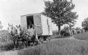
| Date: | 1911 |
|---|---|
| Description: | George W. Hall, Jr.'s wagon show, pulled by horses, travels along a country road. |
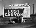
| Date: | |
|---|---|
| Description: | Sign for Lost Canyon, with people standing near a car in the foreground. |
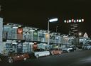
| Date: | |
|---|---|
| Description: | Night view of gift shops, restaurants, and other attractions in a two-story shopping plaza. Several cars are parked along the curb beneath a streetlight in... |

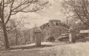
| Date: | 1947 |
|---|---|
| Description: | Colorized postcard of the entrance to the Cave of the Mounds. A curved sign sits on two square stone pillars. The sign reads "Welcome, Cave of the Mounds, ... |
| Date: | |
|---|---|
| Description: | Postcard of the entrance to the Cave of the Mounds. A curved sign sits on two square stone pillars. The sign reads: "Welcome, Cave of the Mounds, Drive In.... |

| Date: | 1938 |
|---|---|
| Description: | A large crowd of men, women, and children sit in the bleachers or stand along the edge of what appears to be the racetrack at the fair grounds. Behind the ... |

| Date: | 1934 |
|---|---|
| Description: | This map shows the area as it appeared in 1848 and includes buildings, land use, and roads with distances to nearby locations. The upper right corner reads... |

| Date: | 1966 |
|---|---|
| Description: | This colored road map shows automobile roads in Wisconsin as well as portions of nearby states. A map key indicates relative sizes of cities and towns. On ... |

| Date: | 1966 |
|---|---|
| Description: | This colored road map shows automobile roads in Wisconsin as well as portions of nearby states. Information on the quality and type of any road shown (inte... |

| Date: | 1971 |
|---|---|
| Description: | This colored map displays Wisconsin and bordering areas of Iowa, Minnesota, and Michigan. There is color-coding on the map to indicate National Forests, an... |

| Date: | 1973 |
|---|---|
| Description: | This colored map displays Wisconsin and bordering areas of Iowa, Minnesota, and Michigan. There is color-coding on the map to indicate National Forests, a... |

| Date: | 1975 |
|---|---|
| Description: | This colored road map of Wisconsin displays "Featured Points of Interest" and "Historical Points of Interest" in the state, including three color photograp... |

| Date: | 1976 |
|---|---|
| Description: | This colored map displays Wisconsin and portions of bordering states, including a detailed map of the Wisconsin Dells area. Surrounding the map are multipl... |

| Date: | 1977 |
|---|---|
| Description: | This colored map displays Wisconsin and portions of bordering states, including a detailed map of the Wisconsin Dells area. Surrounding the map are multipl... |

| Date: | 1967 |
|---|---|
| Description: | Rear view of a man kneeling on the ground while taking a photograph of his wife and son who are posing in front of a large fiberglass statue of a brown and... |
If you didn't find the material you searched for, our Library Reference Staff can help.
Call our reference desk at 608-264-6535 or email us at: