 Filter: Categories of Wisconsin Historical Images
Filter: Subject of Automobile parking
Filter: Subject of land
Filter: Categories of Wisconsin Historical Images
Filter: Subject of Automobile parking
Filter: Subject of land
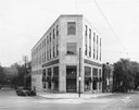
| Date: | 05 20 1930 |
|---|---|
| Description: | The Montgomery Ward Store Building at 100 North Hamilton Street, at the intersection of Pinckney and North Hamilton Streets. The building was designed by L... |
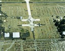
| Date: | 1988 |
|---|---|
| Description: | Aerial view of the 1988 EAA (Experimental Aviation Association) Convention and Fly-in at Wittman Field. On the ground is the Concorde and a B-1 Bomber. |
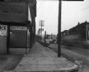
| Date: | 01 08 1946 |
|---|---|
| Description: | View down sidewalk along East Wilson Street at the corner of the South Hancock intersection looking toward the West Wilson Street-King Street intersection.... |
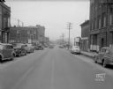
| Date: | 01 08 1946 |
|---|---|
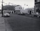
| Description: | East Wilson Street scene looking northeast, taken at site of Reynolds Bus accident. Businesses shown include R & R Cafe at 316 East Wilson Street, Dizon Me... |
| Date: | 01 08 1946 |
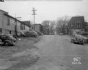
|---|---|
| Description: | South Hancock Street scene looking north uphill across East Wilson Street, taken at site of Reynolds Bus accident. Businesses shown include the Electric Mo... |

| Date: | 10 21 1931 |
|---|---|
| Description: | Elevated view of a colony of squatters in Sunset Point (Hoyt Park, Quarry Park), former quarry site. Home of John & Lottie Corcoran from 1924-1994. |

| Date: | 05 20 1930 |
|---|---|
| Description: | View of the Montgomery Ward Store, on the corner at 102 N. Hamilton Street. |

| Date: | 1929 |
|---|---|
| Description: | View of State Street towards Bascom Hill, with Schaeffer's Lavernette, a soda fountain, Student's Book Exchange, and the University Coop. |
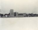
| Date: | 12 18 1955 |
|---|---|
| Description: | Downtown Madison lakeshore taken from Lake Monona in a line with South Carroll Street. Includes State Office Building (2 wings only), 1 West Wilson Street,... |
| Date: | 1938 |
|---|---|
| Description: | View of the Belmont Hotel from the Capitol Grounds. Hommel Bros., with "Good Things to Eat," is on the corner at 20 West Mifflin Street. |
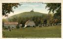
| Date: | 1920 |
|---|---|
| Description: | View of Holy Hill, with a field and the Hillside Hotel in the foreground. Captions read: "America's Favorite Place of Pilgrimage" and "The Holy Hill and Hi... |
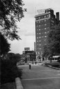
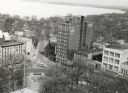
| Date: | 1949 |
|---|---|
| Description: | The 200 block of King Street looking toward the Union Transfer building. |
| Date: | 1925 |
|---|---|
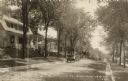
| Description: | View along right curb towards the left side of the tree-lined street, where an automobile is parked. Caption reads: "No. Sheldon St. Richland Center Wis." |
| Date: | 1927 |
|---|---|
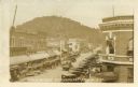
| Description: | Elevated view of Main Street with automobiles lining either side. An ice cream parlor is visible on the right side, as are a dry cleaning and tailoring bu... |
| Date: | 1936 |
|---|---|
| Description: | Slightly elevated view of storefronts on Main Street. Sign on building reads: "Pabst Blue Ribbon Beer." Child standing at pump (water pump?) Two cars parke... |
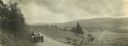
| Date: | |
|---|---|
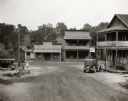
| Description: | Panoramic view of a group of people in cars parked on the side of a road near a weather-worn fence. Hills and a valley are seen in the background. A town c... |
| Date: | 03 1954 |
|---|---|
| Description: | Elevated view looking north from the Wisconsin State Capitol down Hamilton Street. The Belmont Hotel and various storefronts are along Capitol Square. |
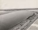
| Date: | 1959 |
|---|---|
| Description: | Elevated view looking south over Lake Monona. Shoreline and automobiles in parking lot in lower right, next to a road. Railroad tracks cross the lake and b... |
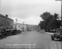
| Date: | |
|---|---|
| Description: | View down a main street with storefronts, showing large power lines stretching into the distance, and a hill in the background. There are cars parked in fr... |
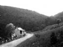
| Date: | |
|---|---|
| Description: | View down hillside toward the Lincoln Highway and a Revolutionary War shot factory, surrounded by woods and hills. |
If you didn't find the material you searched for, our Library Reference Staff can help.
Call our reference desk at 608-264-6535 or email us at: