 Filter: Categories of Wisconsin Historical Images
Filter: Subject of Battles
Filter: Creator Name of Unknown
Filter: Categories of Wisconsin Historical Images
Filter: Subject of Battles
Filter: Creator Name of Unknown

| Date: | 1755 |
|---|---|
| Description: | Map of New England, with three inset maps of Fort Oswego, Fort du Quesne, and Fort Frederick. It shows colonies, a few cities, forts (marked as French or E... |

| Date: | 1775 |
|---|---|
| Description: | Map of Boston and surrounding regions, from Massachusetts Bay to the Connecticut River, and including part of southern New Hampshire. It shows the colonies... |
| Date: | |
|---|---|
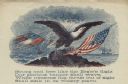
| Description: | Letterhead of an eagle sitting on a rock. The American flag is on the right, and the first Confederate flag, which is tattered and being struck by lightnin... |
| Date: | 01 28 1862 |
|---|---|
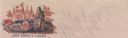
| Description: | Letterhead depicting a scene in the Battle of Big Bethel, in which Lieutenant John T. Greble refused to pull back, as he continued to fire his last cannon.... |

| Date: | 1918 |
|---|---|
| Description: | Poster with an illustration of a young drummer boy leading troops carrying ragged flags into battle. There is a large transparent figure of Marianne in the... |

| Date: | 1900 |
|---|---|
| Description: | A hand-drawn map of the battlefield of the Battle of Chickamauga. |

| Date: | 1916 |
|---|---|
| Description: | Still of actors portraying soldiers in a battle. Caption reads: "King Lear performance (for motion picture?)" |
If you didn't find the material you searched for, our Library Reference Staff can help.
Call our reference desk at 608-264-6535 or email us at: