Filter: Categories of Wisconsin Historical Images
Filter: Subject of Battles
Filter: Subject of streets
Filter: Categories of Wisconsin Historical Images
Filter: Subject of Battles
Filter: Subject of streets

| Date: | 1865 |
|---|---|
| Description: | This detailed map of the area between Richmond and Petersburg shows fortifications, roads, railroads, towns, street patterns of Petersburg and Richmond, dr... |

| Date: | |
|---|---|
| Description: | This detailed map shows fortifications, headquarters, location and dates of battles, street outline of Atlanta, roads, railroads, vegetation, drainage, rel... |

| Date: | 1862 |
|---|---|
| Description: | This detailed map shows batteries and rifle pits, railroads, common and military roads, turnpikes, city streets and names, bridges, ferries, rural houses a... |
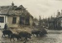
| Date: | 1914 |
|---|---|
| Description: | Slightly elevated view of soldiers and civilians near the damaged Customs Building. Broken furniture and rubble is piled in front of the building. There ar... |

| Date: | 09 28 1914 |
|---|---|
| Description: | Town of Saales. Bombarded by the French on September 28. |

| Date: | |
|---|---|
| Description: | Town of Saales in the Vosges. Debris is on the ground and buildings are damaged. There are wooded hills in the distance beyond the town. The town hall (Rat... |

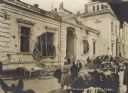
| Date: | |
|---|---|
| Description: | Saales in Alsace. Bombarded by the French on September 28, 1914. Handwritten at bottom left: "Saales." |

| Date: | |
|---|---|
| Description: | Fort Fliron was one of the fortifications surrounding the Belgian City of Liege. It was captured by the Germans in August, 1914. |

| Date: | 1914 |
|---|---|
| Description: | German aerial bombardment of Antwerp through the use of zeppelin airships. |
If you didn't find the material you searched for, our Library Reference Staff can help.
Call our reference desk at 608-264-6535 or email us at: