 Filter: Categories of Wisconsin Historical Images
Filter: Subject of Bays
Filter: Community of Green Bay
Filter: Creator Name of Unknown
Filter: Categories of Wisconsin Historical Images
Filter: Subject of Bays
Filter: Community of Green Bay
Filter: Creator Name of Unknown

| Date: | 1930 |
|---|---|
| Description: | This map shows a plat of the town, local streets, railroads, creeks, part of Fox River, and part of the bay of Green Bay. The location of the original fort... |

| Date: | 1914 |
|---|---|
| Description: | This map has relief shown by hachures and shows local streets, wards, districts, railroads, Fox River, and part of Bay of Green Bay. Wards are shown in dar... |
| Date: | |
|---|---|
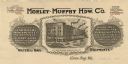
| Description: | Letterhead of the Morley-Murphy Hardware Company, with a three-quarter view of the company building and horse, streetcar, and rail traffic around it. |

| Date: | 1900 |
|---|---|
| Description: | This photocopied map shows private claim owners, buildings, and land use in 1818. Insets show Fort Howard and the caption reads: "A view of the Fox River ... |
| Date: | |
|---|---|
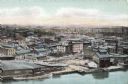
| Description: | Aerial view of Green Bay from the bay. Commercial and industrial buildings are in the foreground. Waterfront businesses include F. Hurlbut Cement and W.W. ... |
| Date: | 1918 |
|---|---|
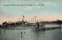
| Description: | The pavilion and bath house at Bay View Beach. Bathers are walking in the shallow water in the foreground. Caption reads: "Pavilion and Bath House, Bay Vie... |

| Date: | 1901 |
|---|---|
| Description: | View across water towards the Steamer "Harriet A. Hart," with many passengers on board, and smoke coming out of the smokestack. Caption reads: "Steamer Har... |
If you didn't find the material you searched for, our Library Reference Staff can help.
Call our reference desk at 608-264-6535 or email us at: