 Filter: Categories of Wisconsin Historical Images
Filter: Subject of Bays
Filter: Year of 1900-1999
Filter: Categories of Wisconsin Historical Images
Filter: Subject of Bays
Filter: Year of 1900-1999

| Date: | 1920 |
|---|---|
| Description: | This map details automobile routes spanning across Wisconsin and parts of Illinois, Michigan, Minnesota, and Iowa. Cities, counties, Lake Michigan, Lake Su... |

| Date: | 1913 |
|---|---|
| Description: | This map details automobile routes throughout the state and parts of Illinois, Minnesota, Michigan, and Iowa. Cities, counties, Lake Michigan, Lake Superio... |

| Date: | 1924 |
|---|---|
| Description: | This map shows automobile routes across the state and into parts of Minnesota, Iowa, Illinois, and Michigan. Cities, Lake Michigan, Lake Superior, Green Ba... |

| Date: | 1919 |
|---|---|
| Description: | This map contains the automobile routes in southern Wisconsin and northern Illinois. Cities, Lake Winnebago and Green Bay are labeled. The orange print on ... |

| Date: | 1915 |
|---|---|
| Description: | This map displays various automobile routes through the state of Wisconsin and parts of Illinois, Iowa, Minnesota, and Michigan. Cities, counties, Lake Mic... |

| Date: | 1913 |
|---|---|
| Description: | This map displays automobile routes across Wisconsin as well as Minnesota, Iowa, Michigan and Illinois. Cities, counties, Lake Michigan, Lake Superior, Gre... |
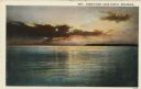
| Date: | 1932 |
|---|---|
| Description: | Color postcard view of a brilliant sunset over Green Bay. There is a forested shoreline in the distance. Caption reads: "Sunset View, Door County, Wisconsi... |
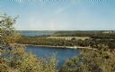
| Date: | 1957 |
|---|---|
| Description: | Elevated view of Little Sister Bay and the surrounding landscape. |
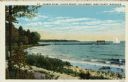
| Date: | 1932 |
|---|---|
| Description: | Colorized postcard of Green Bay from Egg Harbor. A long pier with a rowboat at the side and a sailboat at the end. Caption reads: "Harbor Scene - Alpine Re... |

| Date: | 1932 |
|---|---|
| Description: | This map shows automobile routes across Wisconsin and parts of Illinois, Michigan, Minnesota and Iowa. The Mississippi River, Lake Michigan, Lake Superior,... |

| Date: | 1933 |
|---|---|
| Description: | This road map shows automobile routes across Wisconsin as well as portions of Illinois, Minnesota, Iowa and Michigan. Lakes Michigan, Superior and Winnebag... |

| Date: | 1933 |
|---|---|
| Description: | This map contains automobile routes across Wisconsin and portions of Illinois, Iowa, Minnesota and Michigan as well. The state borders are clearly defined... |

| Date: | 1934 |
|---|---|
| Description: | This map provides automobile routes through Wisconsin along with portions of Illinois, Iowa, Minnesota and Michigan. Lake Superior, Lake Michigan, Green B... |

| Date: | 1934 |
|---|---|
| Description: | This road map contains automobile routes for the state of Wisconsin as well as portions of Minnesota, Illinois, Iowa and Michigan. Lake Michigan, Lake Sup... |
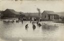
| Date: | 1919 |
|---|---|
| Description: | View towards shoreline with a group of people gathered at a bathing beach. Some people are in the water; other people are standing on the shore fully dress... |
| Date: | 1915 |
|---|---|
| Description: | View of Ephraim from the bay, with a pier in the foreground. Churches are on the left and right, and the Hillside Hotel is in the center near the shore. Ca... |

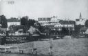
| Date: | 1909 |
|---|---|
| Description: | View across water towards the steep shoreline and lighthouse at Eagle Harbor. |
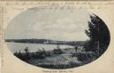
| Date: | 1907 |
|---|---|
| Description: | Oval framed view of Ephraim from across the bay. A man is standing in the foreground. Caption reads: "Greetings from Ephraim, Wis." |
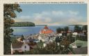
| Date: | 1935 |
|---|---|
| Description: | Hand-colored elevated view from hill of Ephraim, Eagle Bay and Peninsula State Park. Dwellings and a church are in the foreground. Caption reads: "Ephraim,... |
If you didn't find the material you searched for, our Library Reference Staff can help.
Call our reference desk at 608-264-6535 or email us at:
