Filter: Categories of Wisconsin Historical Images
Filter: Subject of Bird's-eye views
Filter: Subject of maps
Filter: Categories of Wisconsin Historical Images
Filter: Subject of Bird's-eye views
Filter: Subject of maps

| Date: | 1879 |
|---|---|
| Description: | Bird's-eye view of Wisconsin State University, now the University of Wisconsin-Madison. Vignettes include Ladies Hall, South Dormitory, University Hall, As... |

| Date: | 1870 |
|---|---|
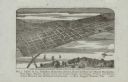
| Description: | Bird's-eye view of the city of Manitowoc with a population of 5,168 inhabitants as it appears in 1870, the year the village was granted a city charter by t... |

| Date: | |
|---|---|
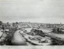
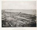
| Description: | Looking West from Knight Block, with shipping piers and sailing ships on right side, railroad on left, trees in background. Horse-drawn carriages on street... |
| Date: | 1909 |
|---|---|
| Description: | Illustration of town. Caption reads: "Bird's-eye View, Lyons, Wisconsin. A Village of natural environments, choice residence locations, desirable factory s... |

| Date: | 1905 |
|---|---|
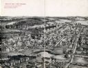
| Description: | Bird's-eye view of Manitowoc on the shores of Lake Michigan. A map of the northeastern part of the United States at the top indicates Manitowoc's location ... |

| Date: | 1862 |
|---|---|
| Description: | Birds-eye view of a Wisconsin Civil War regiment on parade in Fond du Lac, as drawn by Louis Kurz from the Marr Street Methodist Church. The regiment canno... |
| Date: | 08 1861 |
|---|---|
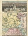
| Description: | Large-format, illustrated stationery purchased by Rudolph Fine, a member of the 6th Wisconsin Infantry in August, 1861, showing the Capitol (in actuality, ... |

| Date: | 1887 |
|---|---|
| Description: | A bird's-eye map of Menekaune, Menominee and Marinette. |

| Date: | 1630 |
|---|---|
| Description: | One of the few maps by Dutch cartographer Willem Blaeu depicting the Americas, this map shows regions, settlements, islands, mountains, forests, rivers, an... |

| Date: | 1719 |
|---|---|
| Description: | This extremely detailed and ornate map shows the cities, Native American land, mountains, lakes, rivers, and European claims of North America. An inset map... |
| Date: | 1892 |
|---|---|
| Description: | Bird's-eye view of Cudahy showing stock yards and the Cudahy packing houses. A train runs through the center of the image on the Chicago & Northwestern Rai... |
| Date: | 1880 |
|---|---|
| Description: | Bird's-eye map of the city of Madison. Caption reads: "City of Madison — From Park's 'History of Madison, Dane County, and Surrounding Towns.'" The text un... |
If you didn't find the material you searched for, our Library Reference Staff can help.
Call our reference desk at 608-264-6535 or email us at: