 Filter: Categories of Wisconsin Historical Images
Filter: Subject of Boats and boating
Filter: Year of 1900-1999
Filter: Year of 1990-1999
Filter: Categories of Wisconsin Historical Images
Filter: Subject of Boats and boating
Filter: Year of 1900-1999
Filter: Year of 1990-1999
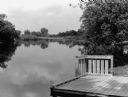
| Date: | 06 1996 |
|---|---|
| Description: | "This is the boat landing at Rivers Edge Park." |

| Date: | 1990 |
|---|---|
| Description: | This map shows various types of trails, boat landings, canoe areas, public beaches, picnic areas, campgrounds, golf courses, public tennis courts, and othe... |

| Date: | 1994 |
|---|---|
| Description: | This map shows historical sites, picnic grounds, public boat landings, canoe and motor boat trips, and resort locations. The left margin of the map include... |
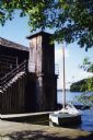
| Date: | 1997 |
|---|---|
| Description: | A vertical-log elevator shaft at one end of a vertical-log two-story boathouse; there is a door at the base of the elevator. Wood steps with a pipe railing... |
If you didn't find the material you searched for, our Library Reference Staff can help.
Call our reference desk at 608-264-6535 or email us at: