 Filter: Categories of Wisconsin Historical Images
Filter: Subject of Bridges
Filter: Creator Name of Unknown
Filter: Community of La Crosse
Filter: Categories of Wisconsin Historical Images
Filter: Subject of Bridges
Filter: Creator Name of Unknown
Filter: Community of La Crosse
| Date: | 1900 |
|---|---|
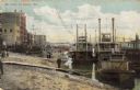
| Description: | Riverboats tied at the levee in La Crosse with the Gypsy in the foreground. Caption reads: "The Levee, La Crosse, Wis." |
| Date: | 1910 |
|---|---|
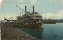
| Description: | The sidewheel packet, Quincy, tied up at the levee. Bridge in background. Later named J.S. Caption reads: "Steamer Quincy at Levee, La... |
| Date: | 1935 |
|---|---|
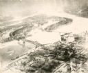
| Description: | An aerial view of La Crosse and the Mississippi River with the bridge drawn in to show what the finished product would look like. |

| Date: | 1940 |
|---|---|
| Description: | Aerial view of the bridge spanning the Mississippi River in La Crosse. |
| Date: | 1905 |
|---|---|
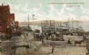
| Description: | View from the top of a railroad car on railroad tracks along the Mississippi River shoreline. Ships are along the shoreline on the right, and railroad trac... |
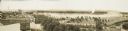
| Date: | 1900 |
|---|---|
| Description: | Four-panel Panoramic view of La Crosse. Indentifiable businesses in view include: J. Hogan Wholesale Grocer, T.H. Spence Drug Co., Union Refrigerator Trans... |
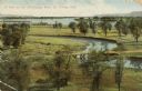
| Date: | 1909 |
|---|---|
| Description: | Elevated view of winding tributaries leading to Mississippi River. A road passes over a bridge in the foreground. Caption reads: "A View on the Mississippi... |

| Date: | 1900 |
|---|---|
| Description: | This map of La Crosse shows twenty wards, some rural lots with acreages, streets, railroads, depots, bridges, cemeteries, parks, schools, islands, and the ... |

| Date: | 1900 |
|---|---|
| Description: | The map is watercolor, pencil, and ink on tracing cloth and shows plats of both cities, local streets, railroads, mills, township divisions, bridges, and p... |

| Date: | 1876 |
|---|---|
| Description: | This map is ink on tracing cloth and shows the Black River, French Slough, Little French Slough, the southern portion of North La Crosse, the Milwaukee & S... |

| Date: | |
|---|---|
| Description: | A bathing beach on an island near a bridge, with people in the water and on the beach within an enclosed area. A canoe and rowboat are pulled up on the sho... |

| Date: | |
|---|---|
| Description: | Illustration of a fish hatchery on the Mississippi River. A steamboat is on the left near a bridge. Caption reads: "Fish Hatchery, La Crosse, Wis." |

| Date: | |
|---|---|
| Description: | Hand-colored view from the shoreline towards a lumber raft. Caption reads: "Steamer Kit Carson Towing Largest Lumber Raft ever taken down the Mississippi R... |

| Date: | |
|---|---|
| Description: | View from shoreline towards the paddle steamer "G.W. Hill" on the Mississippi River. Caption reads: "Steamer G.W. Hill taking excursion out of La Crosse, W... |

| Date: | |
|---|---|
| Description: | Hand-colored view of the arched stone bridge over the lagoon. Caption reads: "Lagoon Bridge, Pettibone Park, La Crosse, Wis." |
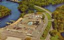
| Date: | |
|---|---|
| Description: | Aerial view of the Holiday Inn, between La Crosse on Barron Island in the beautiful Mississippi. A curved road is leading to a bridge across the Mississipp... |
If you didn't find the material you searched for, our Library Reference Staff can help.
Call our reference desk at 608-264-6535 or email us at: