 Filter: Categories of Wisconsin Historical Images
Filter: Subject of Buildings
Filter: Type of Map or Atlas
Filter: Categories of Wisconsin Historical Images
Filter: Subject of Buildings
Filter: Type of Map or Atlas

| Date: | 10 1891 |
|---|---|
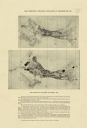
| Description: | This blueprint map shows land ownership and buildings. Text below the title reads: "The La Crosse Heights include the ridge of land with the spurs projecti... |

| Date: | 1920 |
|---|---|
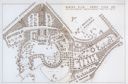
| Description: | This hand-colored bird's-eye-view map shows roads, parks, golf club, schools, buildings, landscaping, and part of Lake Wingra. |

| Date: | 1926 |
|---|---|
| Description: | This blueprint map shows the land and its uses near Two Rivers Harbor. Lake Michigan is labeled on the left. Roads and buildings are also labeled. Original... |

| Date: | 1894 |
|---|---|
| Description: | This map shows railroads, street railways, ward lines, land parcels, streets, schools and public buildings. Ward lines are highlighted in red. Lake Michiga... |

| Date: | 1926 |
|---|---|
| Description: | This blueprint map shows the harbor at Kenosha, also showing buildings surrounding the harbor, roads, and railroads. Original caption in red states: "Areas... |
| Date: | 1918 |
|---|---|
| Description: | The map on the top shows the building situation in Madison in 1899, while the bottom map shows the building situation in 1916. Includes text in the lower m... |

| Date: | 1905 |
|---|---|
| Description: | This blueprint map shows buildings and roads on Bascom Hill. University Avenue, Park street, Charter Street, and Lincoln Drive are labeled. Lake Mendota is... |

| Date: | 1975 |
|---|---|
| Description: | This map shows transportation routes taken by public transit. Includes a key to bus routes, schedule, and transit information. Includes labels for streets,... |
| Date: | 1913 |
|---|---|
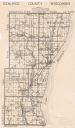
| Description: | This map shows landownership, rural mail routes, rural buildings, railroads, U.S. national highways, state trunk highways, county trunk highways, township... |

| Date: | 1900 |
|---|---|
| Description: | This photocopy map shows proposed buildings and building use at Fort Crawford. |

| Date: | 1900 |
|---|---|
| Description: | This photocopy map shows marshes, woods, buildings, and selected features including islands, mounds, old Fort Crawford, and "new site for a fort in questio... |
| Date: | 1930 |
|---|---|
| Description: | This photocopy map includes cross section of buildings. |

| Date: | 1990 |
|---|---|
| Description: | This map, in addition to the Fort ground and buildings, shows owners of outbuildings, heights of buildings in stories, fences, roads, gardens, and cemetery... |

| Date: | 1759 |
|---|---|
| Description: | Map of New Orleans at the start of the French & Indian War, including two inset maps entitled "The Course of the Mississipi River from Bayagoulas to the Se... |

| Date: | 1761 |
|---|---|
| Description: | Map of New Orleans with north oriented towards the upper right corner. It shows the land around the city, the Mississippi River, anchorages, roads leading ... |

| Date: | 1874 |
|---|---|
| Description: | Birds-eye view of Appleton Wisconsin. In the foreground are people fishing, strolling, and looking over the canal towards the Fox River. Streets and buildi... |
| Date: | 1931 |
|---|---|
| Description: | Fold-out map of the zoo inside a publication titled: "The Master Plan For Henry Vilas Park Zoo." Includes Lake Wingra, the lagoon, and the playground. |

| Date: | 1860 |
|---|---|
| Description: | Inset from Map of Dodge County. Caption reads: "Farmer's Brewery, (Beaver Dam) Aman & Schutte, Proprs." A sign on the building reads: "Farmer's Brewery by ... |
If you didn't find the material you searched for, our Library Reference Staff can help.
Call our reference desk at 608-264-6535 or email us at:
