 Filter: Categories of Wisconsin Historical Images
Filter: Subject of Buildings
Filter: County of Sauk
Filter: Subject of roads
Filter: Categories of Wisconsin Historical Images
Filter: Subject of Buildings
Filter: County of Sauk
Filter: Subject of roads
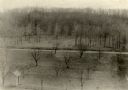
| Date: | |
|---|---|
| Description: | Elevated view of Man Mound outlined in chalk looking south. A road bisects the legs of the effigy mound. A small outbuilding can be seen at left in the for... |

| Date: | 1914 |
|---|---|
| Description: | Colorized postcard of the rock formation called the Devil's Doorway in Devil's Lake State Park. Trees can be seen below. The lake, bluffs, roads and buildi... |

| Date: | 1877 |
|---|---|
| Description: | This 1877 map of Sauk County, Wisconsin, shows the township and range grid, sections, towns, cities and villages, land ownership and acreages, wagon roads,... |

| Date: | 1923 |
|---|---|
| Description: | This topographical map of Devil's Lake State Park, Sauk County, Wisconsin, is based on 1922-1923 surveys of the area by the University of Wisconsin Summer ... |
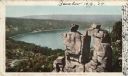
| Date: | 1898 |
|---|---|
| Description: | Colorized postcard view of the Devil's Doorway rock formation overlooking Devil's Lake. Caption reads: "Devil's Doorway, Devil's Lake, Wis." |
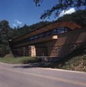
| Date: | |
|---|---|
| Description: | View of a brick and stucco building on the side of a road. It has an overhanging roof line and a cantilevered canopy over the lower entrance. |
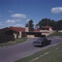
| Date: | |
|---|---|
| Description: | A car is driving up the road to The Spring Green, which has a brick and stucco building with a red roof. An American flag is flying from the canopy above t... |
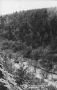
| Date: | 1950 |
|---|---|
| Description: | Text on front reads: "The Old Mill Stream in the Narrows at Rock Springs, Wis." A road and the Narrows Creek run next to each other in an elevated view of ... |

| Date: | 08 25 1911 |
|---|---|
| Description: | Text on front reads: "Down River from Round Bluff, Prairie Du Sac, Wis." A view of the Wisconsin River with buildings and a road along the left shoreline. ... |
If you didn't find the material you searched for, our Library Reference Staff can help.
Call our reference desk at 608-264-6535 or email us at: