 Filter: Categories of Wisconsin Historical Images
Filter: Subject of Buildings
Filter: County of Sauk
Filter: Subject of water
Filter: Categories of Wisconsin Historical Images
Filter: Subject of Buildings
Filter: County of Sauk
Filter: Subject of water
| Date: | 1918 |
|---|---|
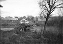
| Description: | View of the Ringling Brothers Circus winter quarters from across the Baraboo River, looking due north. The brick building, center, was one of the two "Cat ... |

| Date: | 1950 |
|---|---|
| Description: | Map showing buildings formerly used as Ringling Brothers Circus winter quarters, along with adjoining buildings. |
| Date: | 05 31 1912 |
|---|---|
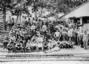
| Description: | Workmen posing outside the dining hall before dinner. |
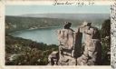
| Date: | |
|---|---|
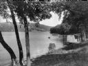
| Description: | Boats park at a landing on Devil's Lake. The small wooden structure stands among trees at the shore. |
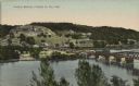
| Date: | |
|---|---|
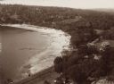
| Description: | Elevated view of the north end of Devil's Lake and Cliff House. A number of buildings are around the shoreline with railroad tracks in the foreground. A lo... |
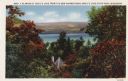
| Date: | 1933 |
|---|---|
| Description: | Colorized postcard of Devil's Lake and bluffs seen through the trees. Some of the trees have autumn color. A roof and chimney are visible. The text at the ... |

| Date: | 1914 |
|---|---|
| Description: | Colorized postcard of the rock formation called the Devil's Doorway in Devil's Lake State Park. Trees can be seen below. The lake, bluffs, roads and buildi... |

| Date: | 1877 |
|---|---|
| Description: | This 1877 map of Sauk County, Wisconsin, shows the township and range grid, sections, towns, cities and villages, land ownership and acreages, wagon roads,... |

| Date: | 1923 |
|---|---|
| Description: | This topographical map of Devil's Lake State Park, Sauk County, Wisconsin, is based on 1922-1923 surveys of the area by the University of Wisconsin Summer ... |
| Date: | 1898 |
|---|---|
| Description: | Colorized postcard view of the Devil's Doorway rock formation overlooking Devil's Lake. Caption reads: "Devil's Doorway, Devil's Lake, Wis." |
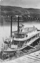
| Date: | 1870 |
|---|---|
| Description: | Elevated view of the steamer Ellen Hardy at dock. Text on the bottom left reads: "'Ellen Hardy' at Pr-Du-Sac. in 1870." The Ellen Hardy belo... |
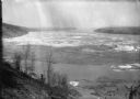
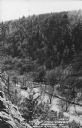
| Date: | 03 1913 |
|---|---|
| Description: | View down steep hill at an ice gorge on a river at a power dam. |
| Date: | 1950 |
|---|---|
| Description: | Text on front reads: "The Old Mill Stream in the Narrows at Rock Springs, Wis." A road and the Narrows Creek run next to each other in an elevated view of ... |

| Date: | 05 10 1907 |
|---|---|
| Description: | Written faintly along bottom: "Sauk Toll Bridge". The view is along the side of the bridge, with buildings and trees on both sides in the foreground. A man... |
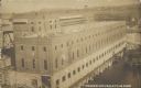
| Date: | 1910 |
|---|---|
| Description: | Text on front reads: "Power House at the Dam." Elevated view of the powerhouse, which is a very large brick and concrete structure next to the Prairie du S... |

| Date: | 11 28 1908 |
|---|---|
| Description: | Text on front reads: "High Bridge, Baraboo, Wis." A truss bridge over the Baraboo River with a spillway underneath. The shorelines are wooded and buildings... |
| Date: | 1910 |
|---|---|
| Description: | Text on front reads: "Wagon Bridge, Prairie Du Sac, Wis." A long structure over the Wisconsin River. Buildings, bluffs and trees can be seen beyond the far... |

| Date: | 08 25 1911 |
|---|---|
| Description: | Text on front reads: "Down River from Round Bluff, Prairie Du Sac, Wis." A view of the Wisconsin River with buildings and a road along the left shoreline. ... |
If you didn't find the material you searched for, our Library Reference Staff can help.
Call our reference desk at 608-264-6535 or email us at: