 Filter: Categories of Wisconsin Historical Images
Filter: Subject of Buildings
Filter: Subject of business
Filter: Categories of Wisconsin Historical Images
Filter: Subject of Buildings
Filter: Subject of business
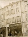
| Date: | 1889 |
|---|---|
| Description: | View of the exterior of the Pharmacie Werner in Boulay/Bolchen, France. This region was part of Germany in 1889. Two men are standing in front of the build... |
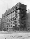
| Date: | 1902 |
|---|---|
| Description: | International Harvester's first headquarters building at 7 Monroe Street on the northwest corner of Michigan Avenue. IHC later sold the building and proper... |

| Date: | 1950 |
|---|---|
| Description: | The Stock Gro Inc. warehouse built in 1915 for A.D. German. Frank Lloyd Wright completed the working drawings in 1914. |
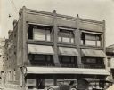
| Date: | 1925 |
|---|---|
| Description: | Awnings stretch over the entrance and windows on the front facade. |
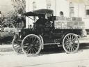
| Date: | 1913 |
|---|---|
| Description: | Man in the driver's seat of an International Model M truck hauling crates of beer labeled "Grand Rapids Brewing Company" and "Petersen Brewing Company." Th... |

| Date: | 1861 |
|---|---|
| Description: | Shows townships and sections, landowners, and woodlands. Includes inset maps of Monroe, Brodhead, Albany, Cadiz, Decatur, Dayton, Clarence, Springfield, Tw... |

| Date: | 1879 |
|---|---|
| Description: | A map of Jackson County, Wisconsin, shows the township and section survey, landownership, towns, villages, buildings, roads, railroads, county land, and st... |

| Date: | 1876 |
|---|---|
| Description: | This 1876 map of Saint Croix County, Wisconsin, shows the township and range grid, sections, towns, cities and villages, land ownership and acreages, wagon... |

| Date: | 1877 |
|---|---|
| Description: | This 1877 map of Trempealeau County, Wisconsin, shows the township and range grid, sections, towns, cities and villages, land ownership and acreages, roads... |

| Date: | 1904 |
|---|---|
| Description: | Map shows townships and sections, landownership and acreages, roads and railroads, and selected buildings. "1904" inscribed on map in pen. Includes busines... |

| Date: | 1876 |
|---|---|
| Description: | Map shows landownership and acreages, roads and railroads, and some buildings. Includes illustrations of local buildings, business directories, and tables ... |

| Date: | 09 1893 |
|---|---|
| Description: | Shows townships and sections, landownership and acreages, buildings, and school districts. Includes vignettes of local buildings, business directory, list ... |

| Date: | 1861 |
|---|---|
| Description: | Shows townships and sections, landowners, and woodlands. Includes inset maps of Monroe, Brodhead, Albany, Cadiz, Decatur, Dayton, Clarence, Springfield, Tw... |

| Date: | 1929 |
|---|---|
| Description: | This map is oriented with north to the upper right. Includes index of retailers and buildings, with some advertisements in margins. |

| Date: | 1871 |
|---|---|
| Description: | This map of Waukesha shows lot owners, buildings, and various plat additions. The margins of the maps include street reference, a Waukesha business directo... |

| Date: | 1857 |
|---|---|
| Description: | This map shows roads, railroads, lakes, and land ownership by name. Also included are illustrations of select business and residences, business directories... |
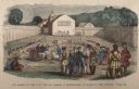
| Date: | 1859 |
|---|---|
| Description: | Hand-colored engraving showing fur company agents making a distribution of goods to Indians, some of whom are seated on the ground, in a fenced courtyard w... |
If you didn't find the material you searched for, our Library Reference Staff can help.
Call our reference desk at 608-264-6535 or email us at: