Filter: Categories of Wisconsin Historical Images
Filter: Subject of Buildings
Filter: Year of 1900-1999
Filter: County of Jefferson
Filter: Categories of Wisconsin Historical Images
Filter: Subject of Buildings
Filter: Year of 1900-1999
Filter: County of Jefferson

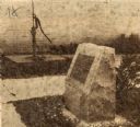
| Date: | 1910 |
|---|---|
| Description: | Black Hawk war monument behind a fence, located at Fort Atkinson. Buildings are in the background. Caption reads: "Black Hawk War Monument, Fort Atkinson, ... |
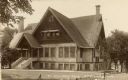
| Date: | 1905 |
|---|---|
| Description: | Front view of the Fort Atkinson Club. Caption reads: "'Fort Atkinson Club' Ft. Atkinson, Wis." |
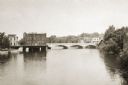
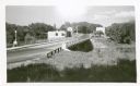
| Date: | 1915 |
|---|---|
| Description: | View across water towards the Main Street Bridge over the Rock River. |

| Date: | 1957 |
|---|---|
| Description: | View of a purple beech tree planted in 1914 in front of the Masonic lodge. |
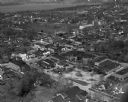
| Date: | 1915 |
|---|---|
| Description: | Elevated view of Fort Atkinson. Caption reads: "Fort Atkinson, Wis." |
| Date: | 1922 |
|---|---|
| Description: | View of Watertown near the Empire Mill, later known as the Globe. |
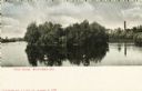
| Date: | 1900 |
|---|---|
| Description: | View across water towards Tivoli Island. There is a smokestack and a building among trees in the distance. Caption reads: "Tivoli Island, Watertown, Wis." |
| Date: | 1947 |
|---|---|
| Description: | Side view of a monument erected on the site of Mrs. Carl Schurz's first kindergarten in America. A hand-pump is in the background near a brick wall. |
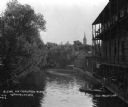
| Date: | 1912 |
|---|---|
| Description: | View looking down the Crawfish River, with a large building with a three-story balcony on the right. A man and a boy are in a boat docked at the steps to t... |
| Date: | 1940 |
|---|---|
| Description: | The bridge over Crawfish River. Buildings are on the other side of the bridge. |
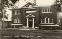
| Date: | 1930 |
|---|---|
| Description: | Front view of a Masonic Temple. Caption reads: "Masonic Temple Palmyra Wis". |
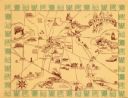
| Date: | 1940 |
|---|---|
| Description: | This map of Watertown pictorially shows historic buildings, locations, and events with dates. The map is printed in brown ink with the border printed in gr... |

| Date: | 06 1959 |
|---|---|
| Description: | This blue line print map shows lot and block numbers and dimensions, fair grounds, schools, court house, parks, and the street numbering system. The Crawfi... |
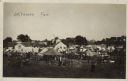
| Date: | 1910 |
|---|---|
| Description: | Elevated view of a community fair with tents set up for exhibits. Two buildings with signs are just beyond the tents on the midway, with signs that read, o... |

| Date: | 1911 |
|---|---|
| Description: | View across a still river with buildings reflected in it. Boathouses are along the shore. Caption reads: "River View from Town Bridge, Jefferson, Wis." |
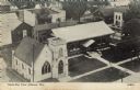
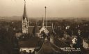
| Date: | 1945 |
|---|---|
| Description: | Elevated view of the public library and the church next door. Caption reads: "Bird's Eye View Jefferson, Wis." |

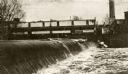
| Date: | 1912 |
|---|---|
| Description: | A group of boys are fishing on the river bank beside a dam. Buildings are on the far bank. Caption reads: "Fishing at Dam on Rock River, Jefferson, Wis." |

| Date: | 1911 |
|---|---|
| Description: | View from shoreline towards a footbridge across the Rock River. People are standing on the bridge. Caption reads: "The Little Red Bridge, Jefferson, Wis." |
If you didn't find the material you searched for, our Library Reference Staff can help.
Call our reference desk at 608-264-6535 or email us at: