 Filter: Categories of Wisconsin Historical Images
Filter: Subject of Business
Filter: County of Milwaukee
Filter: Subject of transportation
Filter: Categories of Wisconsin Historical Images
Filter: Subject of Business
Filter: County of Milwaukee
Filter: Subject of transportation
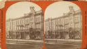
| Date: | 1870 |
|---|---|
| Description: | Stereograph; view of store and adjoining buildings, Wisconsin and Milwaukee Streets. A large statue of a bird sits atop the store in the right of the imag... |
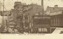
| Date: | 1910 |
|---|---|
| Description: | West from Third Street. Advertising signs for Schlitz, People's Credit Clothing Co., Peoples Dentist, and other businesses line the buildings along the roa... |
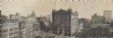
| Date: | |
|---|---|
| Description: | Panoramic view from the top of a building. Home of Merchants and Manufacturers' Association of Milwaukee. Building is in the center of the image, with two ... |
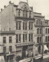
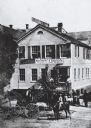
| Date: | 1900 |
|---|---|
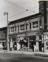
| Description: | Four-level building with shorter buildings flanking it on either side. On the road in front two carriages are visible, drawn by horses. A group of men ar... |
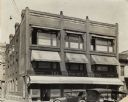
| Date: | 1925 |
|---|---|
| Description: | Awnings stretch over the entrance and windows on the front facade. |
| Date: | 1900 |
|---|---|
| Description: | Previously known as Chestnut Street; view from the corner of 3rd Street. Image looks down the road to the vanishing point on the horizon, where a steeple ... |
| Date: | 1880 |
|---|---|
| Description: | It was in this shop that Christopher Sholes, inventor of the typewriter, did much of his work on various inventions. This photograph may be as early as th... |
| Date: | 1924 |
|---|---|
| Description: | The Milwaukee Journal Building located at 734 North 4th Street. To the right of the building in an alley are circulation trucks. Newsboys and customers are... |
| Date: | 1935 |
|---|---|
| Description: | Skilled Trade Division, at 511-A West Wells Street, Lot 1119. Men's Department-Skilled Trade and Clerical Division; Division for the Physically Disabled. ... |

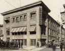
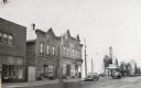
| Date: | 1910 |
|---|---|
| Description: | C.W. McNally Company building at 197-199 Water Street, located just south of the intersection with Chicago Street. This Greek Revival style building was er... |
| Date: | 1940 |
|---|---|
| Description: | View across street of storefronts, including a barbershop, and a sign reading "Alamo" above a marquee that says "Free Poultry and Country Store". The 1100 ... |
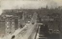
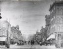
| Date: | 1910 |
|---|---|
| Description: | Elevated view looking east along West State Street between Eighth and Ninth Streets. Numerous buildings line the road, along which cable cars are travelin... |
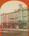
| Date: | 1870 |
|---|---|
| Description: | Stereograph; view of store and adjoining buildings, Wisconsin and Milwaukee Streets. A large statue of a bird sits atop the store in the right of the image... |

| Date: | 1955 |
|---|---|
| Description: | Bottom of the map reads: "PARKING AREA STUDY MILWAUKEE COUNTY ZOOLOGICAL GARDEN SCALE 1"=200" APRIL 21, 1955 TOTAL PARKING AREA - 3736 CARS 31.1 acres". Th... |

| Date: | 1836 |
|---|---|
| Description: | This map shows settlers houses and businesses, trails, and swamps. The relief is shown by hachures. The map includes illustrations of historical buildings ... |

| Date: | 1863 |
|---|---|
| Description: | Includes index to public buildings, churches, schools. Inset: Glidden & Lockwood’s addition. Gives names of some property owners. |

| Date: | 05 1958 |
|---|---|
| Description: | Photocopy of a map created by the City of Milwaukee Master Plan Program City Planning Division in May of 1958 representing 1870 "THE CENTRAL AREA OF THE CI... |

| Date: | |
|---|---|
| Description: | Detailed map showing businesses and lot owners. Includes 2 "continued inset" maps. Includes aerial views, text, and illustartions on verso. |

| Date: | 1947 |
|---|---|
| Description: | This map of Wauwatosa shows 10 zoning class types of land including residential, manufacturing, and business. The map also shows government buildings, some... |

| Date: | 1932 |
|---|---|
| Description: | This map of Granville shows streets, businesses, residential areas, schools, golf courses, and industrial areas. The map shows Granville in March of 1932. ... |
If you didn't find the material you searched for, our Library Reference Staff can help.
Call our reference desk at 608-264-6535 or email us at: