 Filter: Categories of Wisconsin Historical Images
Filter: Subject of Business
Filter: County of Milwaukee
Filter: Categories of Wisconsin Historical Images
Filter: Subject of Business
Filter: County of Milwaukee

| Date: | 05 1958 |
|---|---|
| Description: | Photocopy of a map created by the City of Milwaukee Master Plan Program City Planning Division in May of 1958 representing 1870 "THE CENTRAL AREA OF THE CI... |

| Date: | |
|---|---|
| Description: | Detailed map showing businesses and lot owners. Includes 2 "continued inset" maps. Includes aerial views, text, and illustartions on verso. |

| Date: | 1947 |
|---|---|
| Description: | This map of Wauwatosa shows 10 zoning class types of land including residential, manufacturing, and business. The map also shows government buildings, some... |

| Date: | 1932 |
|---|---|
| Description: | This map of Granville shows streets, businesses, residential areas, schools, golf courses, and industrial areas. The map shows Granville in March of 1932. ... |

| Date: | 1875 |
|---|---|
| Description: | This map shows land ownership by name, plat of town, local streets, fairgrounds, part of White and Fox Rivers. The map includes illustrations of buildings ... |

| Date: | 1964 |
|---|---|
| Description: | This map is a hand-colored blue line print and shows 4 residence zones, 2 business zones, 1 light manufacturing zones, schools, and parks. The zones are ou... |
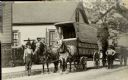
| Date: | |
|---|---|
| Description: | John Hahn stands in the street near his horse-drawn cart. The side of the cart says 'John Hahn Piano & Furniture Moving'. The cart, John Hahn, and the cart... |

| Date: | 1956 |
|---|---|
| Description: | Intended for tourists, this brochure features a map of Milwaukee's central business district as well as general information about parking, beaches and othe... |

| Date: | 1855 |
|---|---|
| Description: | This map shows lot and block numbers, buildings, some landownership, roads, railroads, cemeteries, the Milwaukee River, and Lake Michigan. The map includes... |
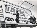
| Date: | 10 09 1965 |
|---|---|
| Description: | Three men are putting up a billboard sign. Two of the men are wearing suits and the third is wearing an overcoat. Caption reads: "A billboard promoting Mil... |

| Date: | 01 23 1968 |
|---|---|
| Description: | A man sitting in an inner tube and wearing swim trunks and a boater hat is using a cane to point to a document, which he is showing to a woman standing in ... |
If you didn't find the material you searched for, our Library Reference Staff can help.
Call our reference desk at 608-264-6535 or email us at: