 Filter: Categories of Wisconsin Historical Images
Filter: Subject of Camping
Filter: Subject of bathing beaches
Filter: Categories of Wisconsin Historical Images
Filter: Subject of Camping
Filter: Subject of bathing beaches
| Date: | |
|---|---|
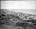
| Description: | Tents line a beach along the Atlantic Ocean. Foliage covers the foreground and several people and vehicles can be seen throughout the camp. |
| Date: | 1930 |
|---|---|
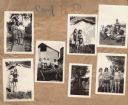
| Description: | Page from the Tansy Camp Fire Girls album kept by Neighborhood House, with groups of girls posing at the end of a pier, in front of tents, on the remains o... |

| Date: | 1932 |
|---|---|
| Description: | This map of Superior shows many points of interests including camping, fair grounds, docks, tourist attractions, lakes, roads, and waterways. |

| Date: | 1962 |
|---|---|
| Description: | This map shows roads, golf courses, ski areas, boat landings, camp sites, waysides, parks, beaches, scenic views, virgin timber tracts, airports, boys and ... |

| Date: | 1962 |
|---|---|
| Description: | This map shows roads, golf courses, ski areas, boat landings, camp sites, waysides, parks, beaches, scenic views, virgin timber tracts, airports, boys and ... |

| Date: | 1990 |
|---|---|
| Description: | This map shows various types of trails, boat landings, canoe areas, public beaches, picnic areas, campgrounds, golf courses, public tennis courts, and othe... |
If you didn't find the material you searched for, our Library Reference Staff can help.
Call our reference desk at 608-264-6535 or email us at: