 Filter: Categories of Wisconsin Historical Images
Filter: Subject of Camping
Filter: Subject of cities and towns
Filter: Categories of Wisconsin Historical Images
Filter: Subject of Camping
Filter: Subject of cities and towns
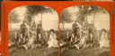
| Date: | 1873 |
|---|---|
| Description: | Stereograph of a group of people posing by the lakeshore of Maple Bluff with tents in the background. One of the woman is holding an archery bow, two women... |
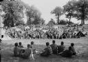
| Date: | 05 27 1944 |
|---|---|
| Description: | Boy Scouts at the Dane District Boy Scout Camporee at Olin Park shown grouped about their tents. |
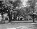
| Date: | 1926 |
|---|---|
| Description: | The tourist camp that the citizens of Chippewa Falls provided free for motorists passing through their community. |

| Date: | 05 1959 |
|---|---|
| Description: | Trailer Convention Officials, including the Mayor and the Police Chief, standing outside near an Airstreamer. |
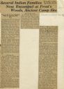
| Date: | 07 05 1928 |
|---|---|
| Description: | Article entitled "Several Indian Families Now Encamped at Frost's Woods, Ancient Camp Site" about Winnebago (Ho-Chunk) Indians camping on the shores of Lak... |

| Date: | 1968 |
|---|---|
| Description: | The map shows fire towers, public camp grounds, roads, snow mobile & riding trails, trout lakes, foot trails, railroads, and National Forest boundaries. |

| Date: | 1975 |
|---|---|
| Description: | A tourist map of Grant County that displays the various activities and attractions found in the cities throughout the county, such as boat landings, fishin... |

| Date: | 1990 |
|---|---|
| Description: | A tourist map of Lafayette County, Wisconsin, that shows the locations of motels, camping, municipal parks, cheese factory tours, waysides, and golf course... |

| Date: | 1964 |
|---|---|
| Description: | This 1964 maps shows roads, boat landings and marinas, campgrounds, canoe trails and portages, and lakes and streams in parts of Vilas, Oneida, and Iron co... |

| Date: | 1926 |
|---|---|
| Description: | This brochure was intended for tourists and shows resorts, lakes and railroads in northwestern Wisconsin and part of Michigan’s upper peninsula. Also inclu... |

| Date: | 1975 |
|---|---|
| Description: | This map shows boundaries, roads, national forest land, bogs and wetlands, lakes, campgrounds, and boat landings. |

| Date: | 1962 |
|---|---|
| Description: | This map shows roads, golf courses, ski areas, boat landings, camp sites, waysides, parks, beaches, scenic views, virgin timber tracts, airports, boys and ... |

| Date: | 1962 |
|---|---|
| Description: | This map shows roads, golf courses, ski areas, boat landings, camp sites, waysides, parks, beaches, scenic views, virgin timber tracts, airports, boys and ... |

| Date: | 1990 |
|---|---|
| Description: | This map shows various types of trails, boat landings, canoe areas, public beaches, picnic areas, campgrounds, golf courses, public tennis courts, and othe... |

| Date: | 1980 |
|---|---|
| Description: | This map shows the locations of 42 businesses, roads, points of interest, recreation sites, camping, the North Country Trail and parking, and boundaries of... |

| Date: | 2000 |
|---|---|
| Description: | This map shows national parks, county and state forests, Indian reservations, municipal land, private land, docks, boat access, camping, and points of inte... |

| Date: | 1960 |
|---|---|
| Description: | This pictorial map shows recreation activities, rivers, lakes, and the history of the area. The map covers Langlade County and parts of adjacent counties. ... |

| Date: | 1925 |
|---|---|
| Description: | This map shows road surfacing, camp sites, rivers, lakes, county boundaries, and cities. Original caption reads, "Compliments Hotel Witter Tour Information... |

| Date: | 1926 |
|---|---|
| Description: | This map shows road surfacings, camp sites, state parks, proposed state parks, rivers, lakes, county boundaries, and cities. Includes portions of Minnesota... |

| Date: | 1966 |
|---|---|
| Description: | This map includes a red overprint on base map and shows the supervisors and district numbers of St. Croix County. Includes diagrams of civil towns, townsh... |
If you didn't find the material you searched for, our Library Reference Staff can help.
Call our reference desk at 608-264-6535 or email us at: