 Filter: Categories of Wisconsin Historical Images
Filter: Subject of Canals
Filter: Subject of human settlements
Filter: Community of Sturgeon Bay
Filter: Categories of Wisconsin Historical Images
Filter: Subject of Canals
Filter: Subject of human settlements
Filter: Community of Sturgeon Bay
| Date: | |
|---|---|
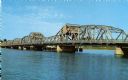
| Description: | View of the bridge spanning the Sturgeon Bay canal. |
| Date: | |
|---|---|
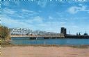
| Description: | View from the shoreline of a bridge spanning the Sturgeon Bay canal. |

| Date: | 1950 |
|---|---|
| Description: | This map of Sturgeon Bay is part of the survey of the northern and northwestern lakes. The map shows lights, railroads, roads, and some public buildings. R... |

| Date: | 06 25 1901 |
|---|---|
| Description: | This map shows beacons, buoys, docks, quarries, streets, and buildings. The map inset shows the Harbor of refuge at entrance to Sturgeon Bay and Lake Michi... |

| Date: | 12 28 1908 |
|---|---|
| Description: | This map shows beacons, buildings, streets, and quarries. Two inset maps include: Vicinity of Sturgeon Bay, Wis. and the Harbor of refuge at entrance to St... |

| Date: | 01 06 1958 |
|---|---|
| Description: | View from jetty out towards Lake Michigan entrance to Ship Canal. A large tank, streetlamp and buildings are on the left. On the opposite jetty is a lighth... |

| Date: | 07 06 1931 |
|---|---|
| Description: | Text on front reads: "Where Green Bay and Sturgeon Bay Meet, Sturgeon Bay, Wis." Aerial view of Sturgeon Bay showing the only bridge in existence at the ti... |
If you didn't find the material you searched for, our Library Reference Staff can help.
Call our reference desk at 608-264-6535 or email us at: