 Filter: Categories of Wisconsin Historical Images
Filter: Subject of Capitols
Filter: County of Dane
Filter: Categories of Wisconsin Historical Images
Filter: Subject of Capitols
Filter: County of Dane
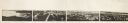
| Date: | 1870 |
|---|---|
| Description: | Panoramic view of Madison, taken from the roof of South Hall. This reduced copy was made from original negatives by E.C. Nielson. Labels for both Lake Mend... |
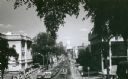
| Date: | 1971 |
|---|---|
| Description: | View of State Street looking east towards the Wisconsin State Capitol from Bascom Hill (on the University of Wisconsin-Madison campus). The Wisconsin Histo... |
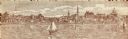
| Date: | 1900 |
|---|---|
| Description: | A view of the city of Madison circa 1900 that was used as a letterhead. |

| Date: | |
|---|---|
| Description: | Elevated view, probably taken from the old Wisconsin State Capitol building, looking down East Washington Avenue toward the water tower. |

| Date: | |
|---|---|
| Description: | Elevated view, probably from the old Wisconsin State Capitol building, looking west down State Street. |

| Date: | 1954 |
|---|---|
| Description: | Wisconsin State Capitol rotunda during the holiday season. A man is standing on a ladder which is on top of scaffolding to decorate the tree. |
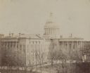
| Date: | 1895 |
|---|---|
| Description: | Elevated view of the Wisconsin State Capitol building. |

| Date: | 1913 |
|---|---|
| Description: | This map shows city wards and government buildings. The map is oriented with north to upper right. |

| Date: | 1934 |
|---|---|
| Description: | This map includes a street index. The map is oriented with the north toward the upper right. Includes handwritten annotations of the 1935 bus routes. |

| Date: | 1940 |
|---|---|
| Description: | Shows property ownership, store divisions, and bus stops. "Sept. 12, 1940." Oriented with north to the right. Insets: "Trade area" location map and enlarge... |

| Date: | 1930 |
|---|---|
| Description: | Indexed map of Madison. Streets, lakes, and points of interest are labelled. Around the edges of the map are the indexed street names. |

| Date: | 1943 |
|---|---|
| Description: | Shows Madison city limits with thick solid lines and ward districts with dotted lines. The wards are numbered, and points of interests and land marks are l... |

| Date: | 1948 |
|---|---|
| Description: | Map created between 1948 and 1954. Shows businesses and lot owners around the State Capitol. Oriented with north to the upper right. Includes "continued in... |

| Date: | 1961 |
|---|---|
| Description: | Shows wards and voting precincts. Published in The Capital times: January 28, 1961. |

| Date: | 1964 |
|---|---|
| Description: | Indexed map. Street names are to the left, map is to the right. Lakes, streets, highways, and points of interest are labelled. |

| Date: | 1978 |
|---|---|
| Description: | Bird’s-eye view map. Shows Madison from the edge of Lake Monona stretching west. Above the map are clouds and in the distance is the edge of the world and ... |

| Date: | 1887 |
|---|---|
| Description: | City water works system map. Pencil annotation on the top right reads: "Period represented is after 1887 and before Aug. 1891". The middle of the map has a... |

| Date: | 1873 |
|---|---|
| Description: | This map shows lots and blocks, additions and subdivisions, and large-scale landownership. The map is oriented with north to the upper right. The map is fr... |

| Date: | 1887 |
|---|---|
| Description: | Shows pipes of various sizes, hydrants with hydrant pressure, valves, wells, and projected lines. |

| Date: | 1888 |
|---|---|
| Description: | Shows ward divisions and street railways, as well as University of Wisconsin buildings, churches, and schools. Cataloged from copy with right and left edge... |
If you didn't find the material you searched for, our Library Reference Staff can help.
Call our reference desk at 608-264-6535 or email us at: