 Filter: Categories of Wisconsin Historical Images
Filter: Subject of Capitols
Filter: Reproduction Rights of For Sale
Filter: Categories of Wisconsin Historical Images
Filter: Subject of Capitols
Filter: Reproduction Rights of For Sale

| Date: | 1887 |
|---|---|
| Description: | City water works system map. Pencil annotation on the top right reads: "Period represented is after 1887 and before Aug. 1891". The middle of the map has a... |

| Date: | 1873 |
|---|---|
| Description: | This map shows lots and blocks, additions and subdivisions, and large-scale landownership. The map is oriented with north to the upper right. The map is fr... |

| Date: | 1887 |
|---|---|
| Description: | Shows pipes of various sizes, hydrants with hydrant pressure, valves, wells, and projected lines. |

| Date: | 1888 |
|---|---|
| Description: | Shows ward divisions and street railways, as well as University of Wisconsin buildings, churches, and schools. Cataloged from copy with right and left edge... |

| Date: | 1892 |
|---|---|
| Description: | Shows pipes of various sizes, hydrants with hydrant pressure, valves, wells, and projected lines. Differs from earlier versions by inclusion of Wingra Park... |

| Date: | 1904 |
|---|---|
| Description: | This map shows numbered wards and plots, labelled streets, and parks in green. |

| Date: | 1907 |
|---|---|
| Description: | Shows public buildings, hotels, fraternity houses, and private houses. Index of fraternities and sororities, residences, public buildings, hotels, places o... |

| Date: | 1908 |
|---|---|
| Description: | Shows pipes of various sizes, hydrants, valves, and wells. "1907" -- Lower margin. Lake Wingra, Lake Monona, and Lake Mendota are labelled. |

| Date: | 1909 |
|---|---|
| Description: | Streets, Lake Wingra, Lake Mendota, and Lake Monona are all labelled. Map reads: "The present park system of Madison comprises 150 acres of improved parks,... |

| Date: | 1920 |
|---|---|
| Description: | Shows wards and selected points of interest. Includes street index. Oriented with north to upper right. |

| Date: | 1927 |
|---|---|
| Description: | Map reads: "Now You Can Visualize Madison". Includes indexes, with points marked 1-98 and a key. Text and illustrations on verso include hotels and seasona... |
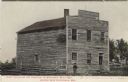
| Date: | |
|---|---|
| Description: | Colorized photographic postcard view of the First Capitol, which is an unpainted wood frame building, with a log fence and a man standing in front. Caption... |
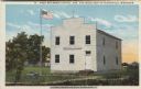
| Date: | |
|---|---|
| Description: | Colorized view of the First State Capitol, which is a wood frame building, painted white, with a flag and a plaque in front. Caption reads: "First Wisconsi... |

| Date: | 1918 |
|---|---|
| Description: | This map shows Madison and includes an index of University of Wisconsin buildings, city buildings, and churches. Lake Mendota, Lake Monona, and Lake Wingra... |

| Date: | 1851 |
|---|---|
| Description: | This map shows plats with lots and block numbers of Madison. The far left corner features "University Ground" and some streets are labeled. Lake Monona is ... |

| Date: | 1855 |
|---|---|
| Description: | This bird's-eye-view map of Madison is looking north across Lake Monona. The map features two women and two men on a lookout on top of a building in the fo... |
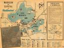
| Date: | 1950 |
|---|---|
| Description: | This map of Madison is also a brochure of activities for vacationers in the area. The map includes indexes and some points of interest are shown pictoriall... |

| Date: | 1925 |
|---|---|
| Description: | This map shows the public schools and their school districts. The bottom of the map reads:" Old buildings and sites in red. New buildings and sites in blac... |

| Date: | 1930 |
|---|---|
| Description: | This map features a legend of highways, railroads, parks, and service stations. The cover and inside of the map features pictures of attractions in Madison... |

| Date: | 1930 |
|---|---|
| Description: | This map of Madison is 7 maps showing the city between 1885 and 1930. Each map has its own annotations of population growth, neighborhoods, and other cha... |
If you didn't find the material you searched for, our Library Reference Staff can help.
Call our reference desk at 608-264-6535 or email us at: