 Filter: Categories of Wisconsin Historical Images
Filter: Subject of Cattle
Filter: Subject of cities and towns
Filter: Categories of Wisconsin Historical Images
Filter: Subject of Cattle
Filter: Subject of cities and towns

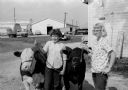
| Date: | 02 1910 |
|---|---|
| Description: | Farmer and two cows standing outside near a barn in winter. |
| Date: | |
|---|---|
| Description: | Elevated view of central square during a winter carnival. Crowds are gathered around a horse-drawn sleigh. Residential buildings are in the background. |
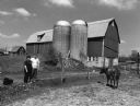
| Date: | 2004 |
|---|---|
| Description: | Jim and Donna Neitzel live on this farm at W2129 Hwy TW (Section 7). This barn has been in the Neitzel name for 100 years and will be deemed a Century Farm... |
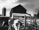
| Date: | 2004 |
|---|---|
| Description: | The Wendling barn was built in 1929 for $10,000. In 1991, cows were milked for the last time. |

| Date: | 1910 |
|---|---|
| Description: | Elevated view of Chicago Union Stock Yards. |

| Date: | |
|---|---|
| Description: | Elevated view of the town with hills in the distance. In the foreground are cattle inside a fence near a cemetery with a windmill. The town is behind furth... |

| Date: | 1909 |
|---|---|
| Description: | Postcard distributed by International Harvester Company featuring a color illustration of a harvesting scene: four people in the fields of Mexico operating... |

| Date: | |
|---|---|
| Description: | A crowd standing in a circle is watching a girl sitting on a calf. In the background is a storefront. |
| Date: | 07 15 1959 |
|---|---|
| Description: | Entries at the 1959 Dane County Junior Fair are, left, Sue Soldwedel, 14, 316 Lakewood Blvd., showing her Hereford junior yearling steer, and right, Linda ... |

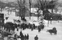
| Date: | 1910 |
|---|---|
| Description: | Men dressed in hats and coats stand with cattle on a snowy street. A large crowd surrounds the men behind a rope. Storefronts and other buildings are on bo... |
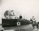
| Date: | |
|---|---|
| Description: | Composite photograph in the "Tall Tale" style. An enormous bovine stands on the front deck of the Pere Marquette 21, a steamer. On the right, on the... |

| Date: | 1946 |
|---|---|
| Description: | This bird's-eye-view map shows scenes of land use and farming superimposed on a map of the United States. Agricultural scenes of farming, livestock, and cr... |

| Date: | 1762 |
|---|---|
| Description: | Map of Virginia and parts of Maryland. It shows borders, boundary lines, Native American tribes and land, towns, forts, roads, mountains, waterfalls, bays,... |
If you didn't find the material you searched for, our Library Reference Staff can help.
Call our reference desk at 608-264-6535 or email us at: