 Filter: Categories of Wisconsin Historical Images
Filter: Subject of Cattle
Filter: Subject of pastures
Filter: Subject of land
Filter: Categories of Wisconsin Historical Images
Filter: Subject of Cattle
Filter: Subject of pastures
Filter: Subject of land
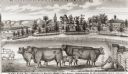
| Date: | 1877 |
|---|---|
| Description: | View of cattle, sheep, and pigs in a pasture on a farm. Two houses are in the distance, and a horse-drawn carriage is moving along the road on the left. Ca... |
| Date: | |
|---|---|
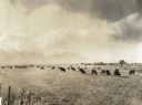
| Description: | Cattle graze in a pasture with mountains in the background. |
| Date: | |
|---|---|
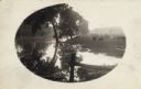
| Description: | River, with fence in foreground, reflecting trees and sunlight. On the right is a field with cows, a man near a fence, and a small dog. |

| Date: | |
|---|---|
| Description: | Distant view of small town surrounded by rolling grassland with cattle grazing in the foreground. Caption reads, "Birds Eye View of Lander, WYO." |

| Date: | |
|---|---|
| Description: | Elevated view of the town with hills in the distance. In the foreground are cattle inside a fence near a cemetery with a windmill. The town is behind furth... |
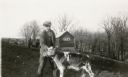
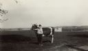
| Date: | 1931 |
|---|---|
| Description: | Claire Alexander posing with a young calf in a pasture near a wooded ravine at his father's farm. There is a manure spreader and shed in the background. |
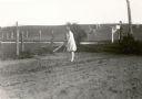
| Date: | 1931 |
|---|---|
| Description: | Lorena Feldmann, 13, hoes in the garden at her family's farm. She is somewhat overdressed for the task in a light coat, white stockings and dress shoes. A ... |

| Date: | |
|---|---|
| Description: | Colorized, elevated view of the Pecatonica River with several of its many curves. Cows are grazing in the pasture in the foreground. The landscape is dotte... |
| Date: | 1933 |
|---|---|
| Description: | Robert Hulburt, age 11 and a student at Hillcrest School, District No. 6, Towns of Waukesha, Pewaukee, Brookield and New Berlin, poses with his heifer in a... |

| Date: | 1762 |
|---|---|
| Description: | Map of Virginia and parts of Maryland. It shows borders, boundary lines, Native American tribes and land, towns, forts, roads, mountains, waterfalls, bays,... |
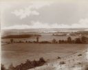
| Date: | 1892 |
|---|---|
| Description: | An elevated view of a gently rolling landscape with cows grazing in the middle distance. At right is a farmhouse and outbuildings. Young trees have been pl... |
If you didn't find the material you searched for, our Library Reference Staff can help.
Call our reference desk at 608-264-6535 or email us at:
