 Filter: Categories of Wisconsin Historical Images
Filter: Subject of Cherokee Indians
Filter: Creator Name of Unknown
Filter: Categories of Wisconsin Historical Images
Filter: Subject of Cherokee Indians
Filter: Creator Name of Unknown
| Date: | |
|---|---|
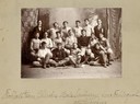
| Description: | Harrell International Institute female students, posed in caps and gowns. |
| Date: | |
|---|---|
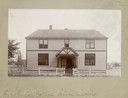
| Description: | A Henry Kendall College School Building. |

| Date: | |
|---|---|
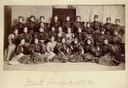
| Description: | A group of Creek, Cherokee, and white girls at Henry Kendall College. |

| Date: | 1897 |
|---|---|
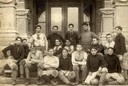
| Description: | Group portrait of the 1897 Henry Kendall College football team, holders of the championship in Indian Territory. The players are Creek, Cherokee, Choctaw,... |
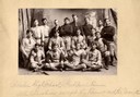
| Date: | 1898 |
|---|---|
| Description: | Group portrait of the 1898 Henry Kendall College football team, made up of four Creek Indians, two Choctaw Indians, one Cherokee Indian, and ten white men. |
| Date: | |
|---|---|
| Description: | Group portrait of a Cherokee Male Seminary football team. |
| Date: | |
|---|---|
| Description: | Group portrait of a Cherokee High School football team. |

| Date: | |
|---|---|
| Description: | A portrait of a Muskogee Presbyterian Church Sunday School Class. Pictured are Cherokee, Creek, and White girls. |

| Date: | 10 1914 |
|---|---|
| Description: | Fourth Annual Conference of American Indians taken in front of Lathrop Hall, University of Wisconsin-Madison campus. Included are: Mr. (William) Kershaw (M... |

| Date: | |
|---|---|
| Description: | A hand-drawn map of Indian boundary lines in southwest Virginia. It also includes the Duck River and the Elk River. |

| Date: | 1779 |
|---|---|
| Description: | Map of South Carolina showing boundary lines, Native American land, precincts, townships, cities, towns, forts, roads, mountains, hills, swamps, islands, a... |

| Date: | 1779 |
|---|---|
| Description: | Map of colonial Georgia showing cities, towns, Native American land and towns, forts, roads, trading paths, islands, mountains, swamps, and rivers. Annotat... |
If you didn't find the material you searched for, our Library Reference Staff can help.
Call our reference desk at 608-264-6535 or email us at: