 Filter: Categories of Wisconsin Historical Images
Filter: Subject of Church buildings
Filter: Subject of human settlements
Filter: Categories of Wisconsin Historical Images
Filter: Subject of Church buildings
Filter: Subject of human settlements
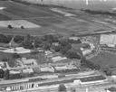
| Date: | 1958 |
|---|---|
| Description: | Aerial photograph showing the J.S. Timlin Lumber Company, 2702 University Avenue, as well as Doctors Park, the Veterans Hospital, and the First Unitarian S... |
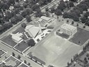
| Date: | |
|---|---|
| Description: | Aerial view of Our Lady Queen of Peace Church. |
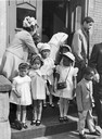
| Date: | 04 06 1969 |
|---|---|
| Description: | Children walking out of church after the Easter Sunday service at St. James United Methodist Church at 1114 West Brown Street. |
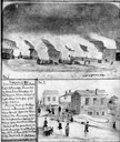
| Date: | 11 08 1906 |
|---|---|
| Description: | Two Civil War watercolor drawings by John Gaddis, Company E, 12th Wisconsin Volunteer Infantry, showing the regiment in bivouac, and later their headquarte... |
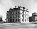
| Date: | 08 01 1929 |
|---|---|
| Description: | The old U.S. Post Office and Federal Building at 4 East Mifflin Street, just months before it was torn down and replaced by Manchester's Department store. ... |

| Date: | 1891 |
|---|---|
| Description: | Bird's-eye map of Wausau, looking north with ninety-eight businesses, industries, churches, schools, and civic buildings identified in location key below i... |
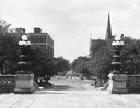
| Date: | 08 24 1945 |
|---|---|
| Description: | View of West Washington Avenue from the Capitol steps, with the Grace Episcopal Church steeple on the right. |
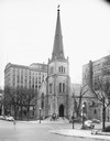
| Date: | 11 24 1946 |
|---|---|
| Description: | Built in 1855 and designed by Milwaukee architect James Douglas, the Grace Episcopal Church is the oldest remaining building on the Capitol Square. Grace E... |

| Date: | 1886 |
|---|---|
| Description: | Bird's-eye view of Bayfield, county seat of Bayfield County. On the lower left side is an inset for Bayfield and the Apostle Islands. |

| Date: | 1853 |
|---|---|
| Description: | Bird's-eye map of Milwaukee looking east toward Lake Michigan from a bluff, long since graded into a slope, at about 6th Street between Wisconsin Avenue an... |
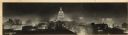
| Date: | 1940 |
|---|---|
| Description: | Panorama view, elevated, of the Wisconsin State Capitol at night from the roof of a building on Monona Avenue. The First National Bank and the Belmont Hote... |
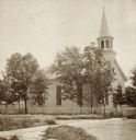
| Date: | 1877 |
|---|---|
| Description: | Stereograph view of the exterior of Assembly Presbyterian Church, surrounded by trees. |
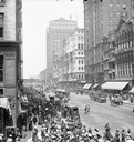
| Date: | |
|---|---|
| Description: | Elevated view of crowd along sidewalks on State Street, and the Masonic Temple from Madison Street. Streetcars and horse-drawn vehicles are in the street. |
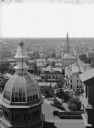
| Date: | |
|---|---|
| Description: | Aerial view northwest from Courthouse of buildings and rooftops. |

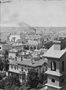
| Date: | |
|---|---|
| Description: | Milwaukee, northeast from Mitchell block. Elevated view of rooftops and buildings. |
| Date: | |
|---|---|
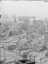
| Description: | View of Milwaukee buildings and rooftops, west from the top of the courthouse. |
| Date: | |
|---|---|
| Description: | View northwest from Exposition Building. Buildings, church, and smokestack in background. |
| Date: | |
|---|---|
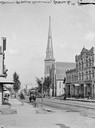
| Description: | View down Grand Avenue from 6th Street. On the street are several horse-drawn vehicles. There is a church in the background. |
| Date: | |
|---|---|
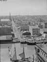
| Description: | Elevated view west from Mitchell Block of warehouses, industrial buildings and a church in the background. In the foreground is a waterway with a schooner ... |
If you didn't find the material you searched for, our Library Reference Staff can help.
Call our reference desk at 608-264-6535 or email us at:
